Hejnice | |
|---|---|
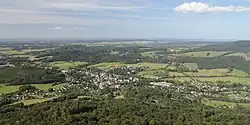
 View from the south | |
 Flag  Coat of arms | |
 Hejnice Location in the Czech Republic | |
| Coordinates: 50°52′38″N 15°11′54″E / 50.87722°N 15.19833°E | |
| Country | |
| Region | Liberec |
| District | Liberec |
| First mentioned | 1381 |
| Government | |
| • Mayor | Jaroslav Demčák |
| Area | |
| • Total | 38.41 km2 (14.83 sq mi) |
| Elevation | 375 m (1,230 ft) |
| Population (2023-01-01)[1] | |
| • Total | 2,791 |
| • Density | 73/km2 (190/sq mi) |
| Time zone | UTC+1 (CET) |
| • Summer (DST) | UTC+2 (CEST) |
| Postal code | 463 62 |
| Website | www |
Hejnice (Czech pronunciation: [ˈɦɛjɲɪtsɛ]; German: Haindorf) is a town in Liberec District in the Liberec Region of the Czech Republic. It has about 2,800 inhabitants.
Administrative parts
The village of Ferdinandov is an administrative part of Hejnice.
Etymology
The original German name of the village Haindorf is based on the German Dorf im Haine, which means "village in the grove". The Czech name was derived from the German one and from háj, i.e. "grove".[2]
Geography
Hejnice is located about 14 km (9 mi) northeast of Liberec. It lies in the valley of the Smědá river under the northern slopes of the Jizera Mountains. The northernmost part of the municipal territory lies in the Frýdlant Hills. The highest peak is Jizera with an altitude of 1,122 m (3,681 ft).
The entire territory of Hejnice is situated in the Jizerské hory Protected Landscape Area. Half of the Czech part of the UNESCO World Heritage Site named Ancient and Primeval Beech Forests of the Carpathians and Other Regions of Europe is situated in the territory of Hejnice.
History
According to legend, a pilgrimage church was founded here already in 1211. The first written mention of Hejnice is from 1381. In the 16th century, iron ore mines were opened. In 1692, count František Gallas established a Franciscan monastery, which helped the visibility of the village. In the 19th century, several textile factories were established in the village and its surroundings. The village of Hejnice was promoted to a town in 1917.[3]
In 1938, Hejnice was annexed by Nazi Germany. From 1938 to 1945, it was administered as part of Reichsgau Sudetenland.
Demographics
|
|
| ||||||||||||||||||||||||||||||||||||||||||||||||||||||
| Source: Censuses[4][5] | ||||||||||||||||||||||||||||||||||||||||||||||||||||||||
Transport
Hejnice is located on a short railway line of local importance from Raspenava to Bílý Potok.[6]
Sights

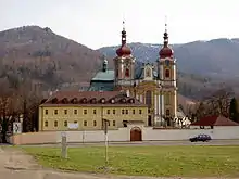
The former Franciscan monastery and its pilgrimage Church of the Visitation are the most valuable buildings in Hejnice. Today the monastery premises are used for cultural and social purposes and provide accommodation.[7]
The Church of the Visitation was originally a small wooden church from the 14th century, which was gradually expanded. The most valuable object is a wooden Gothic sculpture of the Black Madonna from 1380. In front of the church stands the Marian column from 1695.[8]
Notable people
- Oskar Romm (1919–1993), German flying ace
- Katharina Matz (1935–2021), German actress
- Jürgen Kocka (born 1941), German historian
Twin towns – sister cities
 Łęknica, Poland
References
- ↑ "Population of Municipalities – 1 January 2023". Czech Statistical Office. 2023-05-23.
- ↑ Profous, Antonín (1947). Místní jména v Čechách I: A–H (in Czech). pp. 605–606.
- ↑ "Historie" (in Czech). Město Hejnice. Retrieved 2021-08-17.
- ↑ "Historický lexikon obcí České republiky 1869–2011 – Okres Liberec" (in Czech). Czech Statistical Office. 2015-12-21. pp. 3–4.
- ↑ "Population Census 2021: Population by sex". Public Database. Czech Statistical Office. 2021-03-27.
- ↑ "Detail stanice Hejnice" (in Czech). České dráhy. Retrieved 2023-08-12.
- ↑ "Klášter Hejnice" (in Czech). Město Hejnice. Retrieved 2022-10-18.
- ↑ "Kostel Navštívení Panny Marie" (in Czech). Město Hejnice. Retrieved 2022-10-18.
- ↑ "Odkazy" (in Czech). Město Hejnice. Retrieved 2020-07-22.