Rodney Local Board | |
|---|---|
 | |
| Country | New Zealand |
| Region | Auckland |
| Territorial authority | Auckland Council |
| Ward | Rodney Ward |
| Legislated | 2010 |
| Government | |
| • Chair | Brent Bailey (RF) |
| • Deputy Chair | Louise Johnston (RF) |
| Area | |
| • Land | 2,275.08 km2 (878.41 sq mi) |
| Population (June 2023)[2] | |
| • Total | 81,000 |
Local Board Members | |
|---|---|
| Structure | |
Rodney First | 5 / 9 |
Independent | 3 / 9 |
Not afilliated | 1 / 9 |
| Elections | |
Last election | 2022 |
Next election | 2025 |
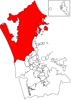
Rodney Local Board is one of the 21 local boards of Auckland Council, and is administered by the ward councillor representing Rodney Ward. Located in the northern part of the Auckland region, it is named after the former Rodney District which existed before its amalgamation into Auckland Council in 2010. Nine elected Local Board members sit on the board.
The Rodney Local Board is charged with decision-making on local issues, activities, and services, and provide input into regional strategies, policies, plans, and decisions.[3]
Governance
The ward is divided into four parts, each containing a number of towns and settlements:
- Kumeū subdivision: Kumeū, Helensville, Muriwai, Kaukapakapa and South Head
- Dairy Flat subdivision: Dairy Flat, Coatesville, Wainui and Waitoki
- Warkworth subdivision: Warkworth, Matakana, Leigh, Puhoi, Ahuroa, Kawau Island
- Wellsford subdivision: Wellsford, Te Ārai, Pākiri, Port Albert, Tapora[3]
Demographics
Rodney ward covers 2,275.08 km2 (878.41 sq mi)[1] and had an estimated population of 81,000 as of June 2023,[2] with a population density of 36 people per km2.
2022 local elections
- Geoff Upson, (no afilliation) (Kumeū) 5340 Votes
- Tim Holdgate, Independent (Warkworth) 4696 Votes
- Guy Wishart, Rodney First (Kumeū) 3978 Votes
- Brent Bailey, Chair. Rodney First (Kumeū) 3708 Votes
- Mark Dennis, Rodney First (Kumeū) 3467 Votes
- Ivan Wagstaff, Rodney First (Warkworth) 3346 Votes
- Michelle Lisa Carmichael, Independent (Warkworth) 3143 Votes
- Colin Smith, Independent (Wellsford) 1,303 votes
- Louise Johnston, Deputy Chair. Rodney First (Dairy Flat) elected unopposed
2019 local elections
- Phelan Pirrie, Chair. Rodney First (Kumeū) 5790 Votes
- Beth Houlbrooke, Deputy Chair. Rodney First (Warkworth) 4993 Votes
- Brent Bailey, Rodney First (Kumeū) 4520 Votes
- Danielle Hancock, Rodney First (Kumeū) 4134 Votes
- Vicki Kenny, Rodney First (Kumeū) 4089 Votes
- Tim Holdgate, Independent (Warkworth) 3782 Votes
- Steven Garner, Rodney Now (Warkworth) 3184 Votes
- Colin Smith, Independent (Wellsford) elected unopposed
- Louise Johnston, Rodney First (Dairy Flat) elected unopposed
2016 local elections
- Phelan Pirrie, Rodney First, Deputy Chair (Kumeū) 4873 Votes
- Cameron Brewer, Rodney First, (Kumeū) 4018 Votes
- Allison Roe, Rodney First, (Warkworth) 3969 Votes
- Tessa Berger, Independent (Warkworth) 3935 Votes
- Brenda Steele, Independent (Kumeū) 3922 Votes
- Brent Bailey, Rodney First (Kumeū) 3518 Votes
- Beth Houlbrooke, Rodney First, Chair (Warkworth) 3230 Votes
- Louise Johnston, Independent (Dairy Flat) 906 Votes
- Colin Smith, Independent (Wellsford)
2013 local elections
The members elected in the 2013 local body elections:
- Brenda Steele, Chair (Kumeū) 3045 Votes
- Steven Garner, Deputy Chair(Warkworth) 2723 Votes
- Thomas Grace (Kumeū) 2587 Votes
- Phelan Pirrie (Kumeū) 2557 Votes
- Warren Flauntey (Kumeū) 2512 Votes
- Beth Houlbrooke (Warkworth) 2323 Votes
- Greg Sayers (Warkworth) 1837 Votes
- John McClean (Dairy Flat) 683 Votes
- James Colville (Wellsford) 534 Votes
2010 local elections
The members elected in the 2010 local body elections:
- Bob Howard, Chair (Kumeū) 3503 Votes
- Warren Flauntey (Kumeū) 3575 Votes
- Brenda Steele (Kumeū) 3349 Votes
- Thomas Grace (Kumeū) 3388 Votes
- John McClean (Dairy Flat) 836 Votes
- Steven Garner (Warkworth) 3809 Votes
- June Turner (Warkworth) 3533 Votes
- Tracey Martin (Warkworth) 3610 Votes
- James Rolf (replaced by James Colville before term ended) (Wellsford)
References
- 1 2 "ArcGIS Web Application". statsnz.maps.arcgis.com. Retrieved 24 February 2022.
- 1 2 "Subnational population estimates (RC, SA2), by age and sex, at 30 June 1996-2023 (2023 boundaries)". Statistics New Zealand. Retrieved 25 October 2023. (regional councils); "Subnational population estimates (TA, SA2), by age and sex, at 30 June 1996-2023 (2023 boundaries)". Statistics New Zealand. Retrieved 25 October 2023. (territorial authorities); "Subnational population estimates (urban rural), by age and sex, at 30 June 1996-2023 (2023 boundaries)". Statistics New Zealand. Retrieved 25 October 2023. (urban areas)
- 1 2 "Rodney Local Board". aucklandcouncil.govt.nz. Auckland Council.