Rainbows End | |
|---|---|
 Rainbows End Reserve | |
| Coordinates: 36°23′10″S 174°43′08″E / 36.386°S 174.719°E | |
| Country | New Zealand |
| Region | Auckland Region |
| Ward | Rodney ward |
| Community board | Rodney Local Board |
| Electorates | |
| Government | |
| • Territorial Authority | Auckland Council |
| Area | |
| • Total | 0.22 km2 (0.08 sq mi) |
| Population (June 2023)[2] | |
| • Total | 100 |
| • Density | 450/km2 (1,200/sq mi) |
Rainbows End is a rural settlement at the end of Green Road between the Oak River and Matakana River in Auckland Region. Matakana is 4.5 km (2.8 mi) to the north. Sandspit is across the Oak River directly south.[3]
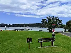
Rainbows End Reserve is a small waterfront park with a boat ramp and jetty.[4][5]
Demographics
Statistics New Zealand describes Rainbows End as a rural settlement, which covers 0.22 km2 (0.085 sq mi)[1] and had an estimated population of 100 as of June 2023,[2] with a population density of 455 people per km2. Rainbows End is part of the larger Dome Valley-Matakana statistical area.[6]
| Year | Pop. | ±% p.a. |
|---|---|---|
| 2006 | 81 | — |
| 2013 | 81 | +0.00% |
| 2018 | 111 | +6.50% |
| Source: [7] | ||
Rainbows End had a population of 111 at the 2018 New Zealand census, an increase of 30 people (37.0%) since the 2013 census, and an increase of 30 people (37.0%) since the 2006 census. There were 51 households, comprising 54 males and 57 females, giving a sex ratio of 0.95 males per female. The median age was 62.1 years (compared with 37.4 years nationally), with 6 people (5.4%) aged under 15 years, 9 (8.1%) aged 15 to 29, 42 (37.8%) aged 30 to 64, and 54 (48.6%) aged 65 or older.
Ethnicities were 97.3% European/Pākehā, 2.7% Māori, 2.7% Pacific peoples, 2.7% Asian, and 0.0% other ethnicities. People may identify with more than one ethnicity.
Religions were 51.4% irreligious, 37.8% Christian, and 2.7% Muslim. The remaining 8.1% chose not to answer the question.
Of those at least 15 years old, 27 (25.7%) people had a bachelor's or higher degree, and 15 (14.3%) people had no formal qualifications. The median income was $31,700, compared with $31,800 nationally. 21 people (20.0%) earned over $70,000 compared to 17.2% nationally. The employment status of those at least 15 was that 33 (31.4%) people were employed full-time, 15 (14.3%) were part-time, and 3 (2.9%) were unemployed.[7]
References
- 1 2 "ArcGIS Web Application". statsnz.maps.arcgis.com. Retrieved 16 May 2022.
- 1 2 "Subnational population estimates (RC, SA2), by age and sex, at 30 June 1996-2023 (2023 boundaries)". Statistics New Zealand. Retrieved 25 October 2023. (regional councils); "Subnational population estimates (TA, SA2), by age and sex, at 30 June 1996-2023 (2023 boundaries)". Statistics New Zealand. Retrieved 25 October 2023. (territorial authorities); "Subnational population estimates (urban rural), by age and sex, at 30 June 1996-2023 (2023 boundaries)". Statistics New Zealand. Retrieved 25 October 2023. (urban areas)
- ↑ Harriss, Gavin (March 2022). Sandspit, Auckland (Map). NZ Topo Map.
- ↑ "Rainbows End Reserve". Places New Zealand. Retrieved 16 May 2022.
- ↑ "Boat ramps in Rodney (north)". Auckland Council. Retrieved 8 June 2022.
- ↑ 2018 Census place summary: Dome Valley-Matakana
- 1 2 "Statistical area 1 dataset for 2018 Census". Statistics New Zealand. March 2020. 7001234.