| region (mkoa) | |
 | |
| Państwo | |
|---|---|
| Siedziba | |
| Populacja (2012[1]) • liczba ludności |
|
| • gęstość |
32 os./km²[1] |
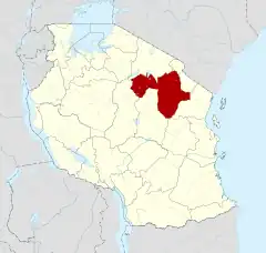
Położenie na mapie Tanzanii | |
| Strona internetowa | |
Manyara – region (mkoa) w Tanzanii.
W 2002 roku region zamieszkiwało 1 037 605 osób. W 2012 ludność wynosiła 1 425 131 osób, w tym 717 085 mężczyzn i 708 046 kobiet, zamieszkałych w 273 284 gospodarstwach domowych[1].
Region podzielony jest na 6 jednostek administracyjnych drugiego rzędu (dystryktów)[1]:
- Babati Town Council
- Babati District Council
- Hanang District Council
- Mbulu District Council
- Simanjiro District Council
- Kiteto District Council
Przypisy
- 1 2 3 4 2012 Population and Housing Census. Population Distribution by Administrative Areas. National Bureau of Statistics Ministry of Finance Dar es Salaam; Office of Chief Government Statistician President’s Office, Finance, Economy and Development Planning Zanzibar, marzec 2013. [dostęp 2016-12-03]. [zarchiwizowane z tego adresu (2016-08-24)].
This article is issued from Wikipedia. The text is licensed under Creative Commons - Attribution - Sharealike. Additional terms may apply for the media files.