| region (mkoa) | |
 | |
| Państwo | |
|---|---|
| Siedziba | |
| Populacja (2012[1]) • liczba ludności |
|
| • gęstość |
124 os./km²[1] |
| Plan | |
 | |
Położenie na mapie Tanzanii | |
| Strona internetowa | |
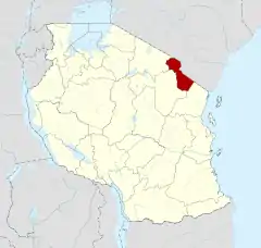
Kilimandżaro – region (mkoa) w Tanzanii.
W 2002 roku region zamieszkiwało 1 376 702 osób. W 2012 ludność wynosiła 1 640 087 osób, w tym 793 140 mężczyzn i 846 947 kobiet, zamieszkałych w 384 867 gospodarstwach domowych[1].
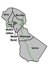
Region podzielony jest na 7 jednostek administracyjnych drugiego rzędu (dystryktów)[1]:
- Hai District Council
- Moshi Municipal Council
- Moshi District Council
- Mwanga District Council
- Rombo District Council
- Same District Council
- Siha District Council
Klimat
| Miesiąc | Sty | Lut | Mar | Kwi | Maj | Cze | Lip | Sie | Wrz | Paź | Lis | Gru | Roczna |
|---|---|---|---|---|---|---|---|---|---|---|---|---|---|
| Średnie temperatury w dzień [°C] | 33.8 | 34.2 | 32.7 | 30.3 | 26.9 | 26.5 | 26.7 | 26.7 | 30.5 | 32.2 | 32.4 | 32.9 | 30,5 |
| Średnie temperatury w nocy [°C] | 18.0 | 18.5 | 19.1 | 19.8 | 18.2 | 14.7 | 15.1 | 15.7 | 17.1 | 18.9 | 20.4 | 19.4 | 17,9 |
| Opady deszczu [mm] | 906.8 | 1386.8 | 1244.6 | 4627.9 | 2174.2 | 61 | 114.3 | 27.9 | 7.6 | 264.2 | 729 | 718.8 | 12 263,1 |
| Źródło: [2] 2016-12-03 | |||||||||||||
Przypisy
- 1 2 3 4 2012 Population and Housing Census. Population Distribution by Administrative Areas. National Bureau of Statistics Ministry of Finance Dar es Salaam; Office of Chief Government Statistician President’s Office, Finance, Economy and Development Planning Zanzibar, marzec 2013. [dostęp 2016-12-03]. [zarchiwizowane z tego adresu (2016-08-24)].
- ↑ 2015 Tanzania in Figures. National Bureau of Statistics Dar es Salaam, czerwiec 2016. [dostęp 2016-12-03]. [zarchiwizowane z tego adresu (2016-12-03)].
This article is issued from Wikipedia. The text is licensed under Creative Commons - Attribution - Sharealike. Additional terms may apply for the media files.