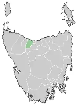
Central Coast Council na mapie Tasmanii
Central Coast Council – obszar samorządu lokalnego (ang. local government area) położony w północnej części Tasmanii. Głównymi ośrodkami regionu są: Ulverstone (siedziba Rady Samorządu) i Penguin, mniejsze ośrodki to: Forth oraz Turners Beach. Central Coast Council zostało założone 2 kwietnia 1993 roku. W czerwcu 2006 roku liczba mieszkańców wynosiła 21259[1], a powierzchnia wynosi 931,1 km².
Granica samorządu na zachodzie stanowi rzeka Blythe, na wschodzie droga Braddons Lookout Road, a od południa szczyt Black Bluff[2]. Głównymi atrakcjami turystycznymi są Leven Canyon[3] i Black Bluff[4].
W celu identyfikacji samorządu Australian Bureau of Statistics wprowadziło czterocyfrowy kod dla gminy Central Coast – 0810[5].
Linki zewnętrzne
- Oficjalna strona Central Coast Council. centralcoast.tas.gov.au. [zarchiwizowane z tego adresu (2009-10-30)].
Przypisy
- ↑ Australian Bureau of Statistics: 3218.0 - Regional Population Growth, Australia, 1996 to 2006, Local Government Area populations and median ages - Tasmania [dostęp 18 listopada 2009]
- ↑ Central Coast Council - Annual Report 2002-2003
- ↑ Leven Canyon [dostęp 18 listopada 2009]
- ↑ Black Bluff [dostęp 18 listopada 2009]
- ↑ Australian Bureau of Statistics. Alphabetic list of Local Government Areas (LGAs) and Statistical Local Areas (SLAs) – Tasmania, [dostęp 30 września 2011].
This article is issued from Wikipedia. The text is licensed under Creative Commons - Attribution - Sharealike. Additional terms may apply for the media files.