Yan District | |
|---|---|
| Daerah Yan | |
| Other transcription(s) | |
| • Jawi | ين |
| • Chinese | 铅县 |
| • Tamil | யான் |
 Seal | |
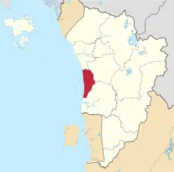
 Location of Yan District in Kedah | |
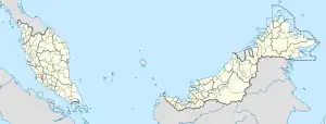
 Yan District Location of Yan District in Malaysia | |
| Coordinates: 5°48′N 100°22′E / 5.800°N 100.367°E | |
| Country | |
| State | |
| Seat | Yan Besar |
| Local area government(s) | Yan District Council |
| Government | |
| • District officer | Mohamad Subhi Abdullah |
| Area | |
| • Total | 241.78 km2 (93.35 sq mi) |
| Population (2010)[2] | |
| • Total | 67,653 |
| • Density | 280/km2 (720/sq mi) |
| Time zone | UTC+8 (MST) |
| • Summer (DST) | UTC+8 (Not observed) |
| Postcode | 06xxx |
| Calling code | +6-04 |
| Vehicle registration plates | K |
Yan District Council Majlis Daerah Yan | |
|---|---|
 | |
| Type | |
| Type | |
| History | |
| Founded | 1 March 1979 |
| Leadership | |
President | Mohamad Subhi Abdullah |
District Secretary | Mohd Akmal Azzimi |
| Website | |
| pbt | |
The Yan District is a district in Kedah, Malaysia. It is bordered by Kota Setar District to the north, Pendang District to the northeast and Kuala Muda District to the south. Yan District is along the coast of the Straits of Malacca. It is the smallest municipality in Kedah.
"Yan Besar" is the administrative town of Yan district, complete with administrative facilities such like Police Stations, magistrate court, district and land office. Its lifestyle is laid-back and slow-paced, with weekend attractions of natural waterfalls nearby. It also attract most pensioners to build their dream house for pleasant retirement or nurture some local fruit orchards. The waterfalls derived from the Jerai Mountain are known as Seri Perigi,[3] Tangga Kenari/Titi Hayun,[4] Batu Hampar [5] and Puteri Mandi.[6]

It is also famous for Mount Jerai, which is the tallest peak in Kedah at 1242 metres (3,235 ft) and is easily accessible from the town. Visitors can climb by stairs to the peak of Mount Jerai via Titi Hayun.
Pulau Bunting Bridge is a bridge that connects Pulau Bunting to Yan district. It is the only bridge connecting an island in Kedah.
Administrative divisions

Yan is divided into 5 mukims, which are:[7]
- Dulang
- Sala Besar
- Singkir
- Sungai Daun
- Yan
Demographics
| Year | Pop. | ±% |
|---|---|---|
| 1991 | 60,483 | — |
| 2000 | 62,217 | +2.9% |
| 2010 | 66,606 | +7.1% |
| 2020 | 73,384 | +10.2% |
| Source: [8] | ||
People from Yan
- Abdullah Hussain – novelist and writer.
- Abdul Rahman Hashim – deceased Inspector General of Police.
Federal Parliament and State Assembly seats
List of Yan district representatives in the Federal Parliament (Dewan Rakyat)
| Parliament | Seat Name | Member of Parliament | Party |
|---|---|---|---|
| P12 | Jerai | Sabri Bin Azit | Perikatan Nasional (PAS) |
List of Yan district representatives in the State Legislative Assembly (Dewan Undangan Negeri)
| Parliament | State | Seat Name | State Assemblyman | Party |
|---|---|---|---|---|
| P12 | N20 | Sungai Limau | Mohd Azam Bin Abd Samat | Perikatan Nasional (PAS) |
| P12 | N21 | Guar Chempedak | Ku Abd Rahman Bin Ku Ismail | Perikatan Nasional (PPBM) |
References
- ↑ "Laman Web Rasmi Pejabat Tanah Yan – Mengenai Kami". pty.kedah.gov.my.
- ↑ "Population Distribution and Basic Demographic Characteristics, 2010" (PDF). Department of Statistics, Malaysia. Archived from the original (PDF) on 22 May 2014. Retrieved 19 April 2012.
- ↑ Seri Perigi at visitkedah.com.my
- ↑ Titi Hayun at visitkedah.com.my
- ↑ Batu Hampar at visitkedah.com.my
- ↑ Puteri Mandi at mdy.gov.my
- ↑ "Kod dan Nama Sempadan Pentadbiran Tanah, Unique Parcel Identifier (UPI) KEDAH" (PDF). Jawatankuasa Teknikal Standard MyGDI (JTSM). 2011.
- ↑ "Key Findings of Population and Housing Census of Malaysia 2020" (pdf) (in Malay and English). Department of Statistics, Malaysia. ISBN 978-967-2000-85-3.