Schneverdingen | |
|---|---|
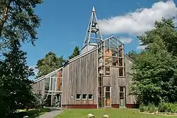
 One World Church | |
 Coat of arms | |
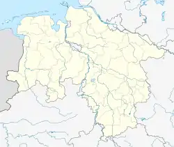
Location of Schneverdingen within Heidekreis district  | |
 Schneverdingen  Schneverdingen | |
| Coordinates: 53°07′00″N 09°48′00″E / 53.11667°N 9.80000°E | |
| Country | Germany |
| State | Lower Saxony |
| District | Heidekreis |
| Subdivisions | 10 districts |
| Government | |
| • Mayor (2019–24) | Meike Moog-Steffens[1] (Ind.) |
| Area | |
| • Total | 234.58 km2 (90.57 sq mi) |
| Elevation | 97 m (318 ft) |
| Population (2021-12-31)[2] | |
| • Total | 18,964 |
| • Density | 81/km2 (210/sq mi) |
| Time zone | UTC+01:00 (CET) |
| • Summer (DST) | UTC+02:00 (CEST) |
| Postal codes | 29640 |
| Dialling codes | 05193, -98, -99, 04265 |
| Vehicle registration | HK, SFA |
| Website | www.schneverdingen.de |
Schneverdingen (German pronunciation: [ˈʃneːvɐdɪŋən]; Low Saxon Snevern) is a city in the northern part of the district of Heidekreis, in Lower Saxony, Germany. It is located in the area known as Lüneburg Heath.
Geography
Location
Schneverdingen is situated approximately 15 km (9 mi) north of Soltau, and 50 km (31 mi) south of Hamburg.
History
Schneverdingen belonged to the Prince-Bishopric of Verden, established in 1180. In 1648 the Prince-Bishopric was transformed into the Principality of Verden, which was first ruled in personal union by the Swedish Crown - interrupted by a Danish occupation (1712–1715) - and from 1715 on by the Hanoverian Crown. The Kingdom of Hanover incorporated the Principality in a real union and the Princely territory, including Schneverdingen, became part of the new Stade Region, established in 1823.
Government
Town twinning
Schneverdingen is twinned with:
Places of interest
- Höpen Airfield
- Reinsehlen Camp
- Heidegarten
- Pietzmoor
References
- ↑ "Verzeichnis der direkt gewählten Bürgermeister/-innen und Landräte/Landrätinnen". Landesamt für Statistik Niedersachsen. April 2021.
- ↑ "LSN-Online Regionaldatenbank, Tabelle A100001G: Fortschreibung des Bevölkerungsstandes, Stand 31. Dezember 2021" (in German). Landesamt für Statistik Niedersachsen.