Saint-Girons | |
|---|---|
Subprefecture and commune | |
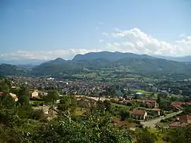
 General view of the town | |
.svg.png.webp) Coat of arms | |
Location of Saint-Girons | |
 Saint-Girons  Saint-Girons | |
| Coordinates: 42°59′09″N 1°08′48″E / 42.9858°N 1.1467°E | |
| Country | France |
| Region | Occitania |
| Department | Ariège |
| Arrondissement | Saint-Girons |
| Canton | Couserans Ouest |
| Intercommunality | Couserans-Pyrénées |
| Government | |
| • Mayor (2020–2026) | Jean-Noël Vigneau[1] |
| Area 1 | 19.13 km2 (7.39 sq mi) |
| Population | 6,250 |
| • Density | 330/km2 (850/sq mi) |
| Time zone | UTC+01:00 (CET) |
| • Summer (DST) | UTC+02:00 (CEST) |
| INSEE/Postal code | 09261 /09200 |
| Elevation | 387–1,200 m (1,270–3,937 ft) (avg. 391 m or 1,283 ft) |
| 1 French Land Register data, which excludes lakes, ponds, glaciers > 1 km2 (0.386 sq mi or 247 acres) and river estuaries. | |
Saint-Girons (French pronunciation: [sɛ̃ ʒiʁɔ̃] ⓘ; Occitan: Sent Gironç) is a commune in the Ariège department in southwestern France.
History
Antiquity
.jpg.webp)
Unlike its close neighbour Saint-Lizier, Saint-Girons isn't an ancient city; there was however a lucus on its present territory where some Roman finds were made during the construction of the train station in the beginning of the twentieth century. Modern-days district Le Luc is considered to owe its name to this ancient lucus.
Foundation
_-_%C3%89glise_Saint-Girons_-_20070625.jpg.webp)
The city is named after Saint Girons, a saint from fifth-century Landes who evangelized Novempopulania. In the ninth century some of his relics were supposedly buried in Saint Girons' Church, around which the city later developed.
Climate
Saint-Girons has a moderate but warm oceanic climate, that is quite prone to temporary vast extremes in temperature as a result of its inland position.
| Climate data for Saint-Girons, Ariège (1981–2010 averages) | |||||||||||||
|---|---|---|---|---|---|---|---|---|---|---|---|---|---|
| Month | Jan | Feb | Mar | Apr | May | Jun | Jul | Aug | Sep | Oct | Nov | Dec | Year |
| Record high °C (°F) | 22.4 (72.3) |
31.2 (88.2) |
29.0 (84.2) |
29.0 (84.2) |
32.1 (89.8) |
38.9 (102.0) |
38.2 (100.8) |
38.6 (101.5) |
36.5 (97.7) |
33.3 (91.9) |
26.4 (79.5) |
25.0 (77.0) |
38.9 (102.0) |
| Mean daily maximum °C (°F) | 10.3 (50.5) |
11.3 (52.3) |
14.2 (57.6) |
16.0 (60.8) |
19.5 (67.1) |
22.9 (73.2) |
25.5 (77.9) |
25.6 (78.1) |
23.0 (73.4) |
19.0 (66.2) |
13.7 (56.7) |
10.9 (51.6) |
17.7 (63.9) |
| Mean daily minimum °C (°F) | 0.3 (32.5) |
1.1 (34.0) |
3.3 (37.9) |
5.2 (41.4) |
8.9 (48.0) |
12.5 (54.5) |
14.5 (58.1) |
14.3 (57.7) |
11.2 (52.2) |
8.0 (46.4) |
3.5 (38.3) |
0.9 (33.6) |
7.0 (44.6) |
| Record low °C (°F) | −18.7 (−1.7) |
−16.5 (2.3) |
−12.8 (9.0) |
−4.2 (24.4) |
−1.1 (30.0) |
2.2 (36.0) |
5.2 (41.4) |
4.7 (40.5) |
1.3 (34.3) |
−4.0 (24.8) |
−10.2 (13.6) |
−12.3 (9.9) |
−18.7 (−1.7) |
| Average precipitation mm (inches) | 83.3 (3.28) |
61.6 (2.43) |
80.2 (3.16) |
104.6 (4.12) |
101.8 (4.01) |
77.4 (3.05) |
52.2 (2.06) |
72.6 (2.86) |
73.0 (2.87) |
80.1 (3.15) |
82.0 (3.23) |
83.4 (3.28) |
952.2 (37.49) |
| Average precipitation days | 10.4 | 9.2 | 10.7 | 12.0 | 12.2 | 9.3 | 7.2 | 8.9 | 8.6 | 10.5 | 9.8 | 10.0 | 118.9 |
| Average snowy days | 3.1 | 3.4 | 2.7 | 1.0 | 0.2 | 0.0 | 0.0 | 0.0 | 0.0 | 0.2 | 1.4 | 3.1 | 15.1 |
| Average relative humidity (%) | 79 | 77 | 74 | 75 | 78 | 78 | 76 | 78 | 78 | 81 | 81 | 80 | 77.9 |
| Mean monthly sunshine hours | 119.3 | 130.5 | 169.2 | 168.7 | 179.4 | 189.3 | 204.6 | 207.2 | 190.1 | 152.4 | 117.2 | 108.7 | 1,936.3 |
| Source 1: Météo France[3][4] | |||||||||||||
| Source 2: Infoclimat.fr (humidity and snowy days, 1961–1990)[5] | |||||||||||||
Population
Inhabitants of Saint-Girons are called Saint-Gironnais.
|
| ||||||||||||||||||||||||||||||||||||||||||||||||||||||||||||||||||||||||||||||||||||||||||||||||||||||||||||||||||
| Source: EHESS[6] and INSEE (1968-2017)[7] | |||||||||||||||||||||||||||||||||||||||||||||||||||||||||||||||||||||||||||||||||||||||||||||||||||||||||||||||||||
.jpg.webp)
.jpg.webp)
Sport
Stage 8 of the 2009 Tour de France finished in Saint-Girons, after travelling 176 km from Andorra la Vella.
Stage 9 of the 2013 Tour de France started here.
References
- ↑ "Répertoire national des élus: les maires". data.gouv.fr, Plateforme ouverte des données publiques françaises (in French). 2 December 2020.
- ↑ "Populations légales 2021". The National Institute of Statistics and Economic Studies. 28 December 2023.
- ↑ "Données climatiques de la station de Saint-Girons" (in French). Meteo France. Retrieved 8 January 2016.
- ↑ "Climat Midi-Pyrénées" (in French). Meteo France. Retrieved 8 January 2016.
- ↑ "Normes et records 1961-1990: Saint-Girons - Antichan (09) - altitude 411m" (in French). Infoclimat. Retrieved 8 January 2016.
- ↑ Des villages de Cassini aux communes d'aujourd'hui: Commune data sheet Saint-Girons, EHESS (in French).
- ↑ Population en historique depuis 1968, INSEE