Miglos | |
|---|---|
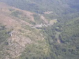
 A general view of Miglos | |
Location of Miglos | |
 Miglos  Miglos | |
| Coordinates: 42°47′33″N 1°36′01″E / 42.7925°N 1.6003°E | |
| Country | France |
| Region | Occitania |
| Department | Ariège |
| Arrondissement | Foix |
| Canton | Sabarthès |
| Intercommunality | Pays de Tarascon |
| Government | |
| • Mayor (2020–2026) | Sébastien Lacroix[1] |
| Area 1 | 18.76 km2 (7.24 sq mi) |
| Population | 122 |
| • Density | 6.5/km2 (17/sq mi) |
| Time zone | UTC+01:00 (CET) |
| • Summer (DST) | UTC+02:00 (CEST) |
| INSEE/Postal code | 09192 /09400 |
| Elevation | 600–1,903 m (1,969–6,243 ft) (avg. 850 m or 2,790 ft) |
| 1 French Land Register data, which excludes lakes, ponds, glaciers > 1 km2 (0.386 sq mi or 247 acres) and river estuaries. | |
Miglos is a commune in the Ariège department in southwestern France.[3]
Geography
It is located in the former High Ariege in the High County Foix, Sabarthès.
The valley opens to the northwest Vicdessos valley at Capoulet, and to the south it forms a large bowl. The valley has an average altitude of 810 metres (2,660 ft).
The limits of the Barony under the former regime were almost the same as those of today. During the revolutionary period the municipality escaped fragmentation.
Population
| Year | Pop. | ±% |
|---|---|---|
| 1962 | 73 | — |
| 1968 | 105 | +43.8% |
| 1975 | 120 | +14.3% |
| 1982 | 94 | −21.7% |
| 1990 | 97 | +3.2% |
| 1999 | 80 | −17.5% |
| 2006 | 104 | +30.0% |
| 2007 | 107 | +2.9% |
| 2012 | 118 | +10.3% |
| 2017 | 117 | −0.8% |
Sights
Château de Miglos: the ruins of this castle are perched on a limestone outcrop 750 metres (2,460 ft) high, a couple of kilometres upstream from the prehistoric caves at Niaux and the commune of Capoulet, in the valley of Vicdessos. It was built towards the beginning of the 13th century, later razed by order of Cardinal Richelieu and largely damaged at the time of the French Revolution.[4]
In 1830, Jean-Louis Hycinthe de Vendômois, heir to the place, saw his residence plundered during the Guerre des Demoiselles (1829–1832) while opposing the peasants of Ariège with Charles X of France.
See also
References
- ↑ "Répertoire national des élus: les maires" (in French). data.gouv.fr, Plateforme ouverte des données publiques françaises. 13 September 2022.
- ↑ "Populations légales 2021". The National Institute of Statistics and Economic Studies. 28 December 2023.
- ↑ INSEE commune file
- ↑ Dubin, Marc (2004). The Rough Guide to the Pyrenees. Rough Guides. p. 261. ISBN 1-84353-196-8.
External links
