Lagarde | |
|---|---|
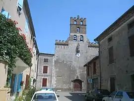
 The church in Lagarde | |
.svg.png.webp) Coat of arms | |
Location of Lagarde | |
 Lagarde  Lagarde | |
| Coordinates: 43°03′01″N 1°56′05″E / 43.0503°N 1.9347°E | |
| Country | France |
| Region | Occitania |
| Department | Ariège |
| Arrondissement | Pamiers |
| Canton | Mirepoix |
| Intercommunality | Pays de Mirepoix |
| Government | |
| • Mayor (2020–2026) | Christian Chaubet[1] |
| Area 1 | 11.93 km2 (4.61 sq mi) |
| Population | 202 |
| • Density | 17/km2 (44/sq mi) |
| Time zone | UTC+01:00 (CET) |
| • Summer (DST) | UTC+02:00 (CEST) |
| INSEE/Postal code | 09150 /09500 |
| Elevation | 316–543 m (1,037–1,781 ft) (avg. 327 m or 1,073 ft) |
| 1 French Land Register data, which excludes lakes, ponds, glaciers > 1 km2 (0.386 sq mi or 247 acres) and river estuaries. | |
Lagarde (French pronunciation: [laɡaʁd]; Occitan: La Garda) is a commune in the Ariège department in southwestern France.
History
On 25 May 1969, the commune of Lagarde was struck by an F3 tornado. It destroyed nearby hamlets and transportation in the village and the surrounding area. A few hours later in the department of Aude the tornado devastated the village of Leuc. Such a wave of powerful tornadoes is rare in France.
Sights
Chateau
The Château de Lagarde is an imposing medieval building constructed in the 11th century with the first square tower (1063–1065) by Ramiro I, King of Aragon and Count of Barcelona. Between the 1176 and 1180 the chateau developed with 4 square towers and with a rectangular entry with a door made out of wood, a drawbridge and ditch at the foot of the walls.

In the middle of the beautiful paved yard is a well which is 62 meters depth and 2 meters in diameter cut with stone 1.20 metres thick. Simon de Montfort, 5th Earl of Leicester allotted the village of Lagarde and its castle to Guy I of Lévis, lieutenant of his army, in 1212. This was conducted after Simon de Montfort convened at Pamiers in a general meeting of nobles, prelates and noted middle-class men, where they drew up a 46 article administration doctrine of the place. It was ratified by the Treaty of Paris and signed on 12 April 1229 on the square of Notre-Dame.

Population
| Year | Pop. | ±% |
|---|---|---|
| 1962 | 165 | — |
| 1968 | 213 | +29.1% |
| 1975 | 185 | −13.1% |
| 1982 | 177 | −4.3% |
| 1990 | 172 | −2.8% |
| 1999 | 194 | +12.8% |
| 2008 | 180 | −7.2% |
See also
References
- ↑ "Répertoire national des élus: les maires". data.gouv.fr, Plateforme ouverte des données publiques françaises (in French). 9 August 2021.
- ↑ "Populations légales 2021". The National Institute of Statistics and Economic Studies. 28 December 2023.