Khamir County
Persian: شهرستان خمیر | |
|---|---|
County | |
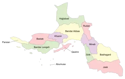
 Location of Khamir County in Hormozgan province (left, purple) | |
 Location of Hormozgan province in Iran | |
| Coordinates: 27°14′N 55°28′E / 27.233°N 55.467°E[1] | |
| Country | |
| Province | Hormozgan |
| Capital | Bandar Khamir |
| Districts | Central, Kohurestan, Ruydar |
| Population (2016)[2] | |
| • Total | 56,148 |
| Time zone | UTC+3:30 (IRST) |
Khamir County (Persian: شهرستان خمیر) is in Hormozgan province, Iran. Its capital is the city of Bandar Khamir.[3]
At the 2006 census, the county's population was 47,545 in 10,320 households.[4] The following census in 2011 counted 52,968 people in 13,245 households.[5] At the 2016 census, the county's population was 56,148 in 16,071 households.[2]
Administrative divisions
The population history and structural changes of Khamir County's administrative divisions over three consecutive censuses are shown in the following table. The latest census shows two districts, four rural districts, and two cities.[2]
After the 2016 census, the village of Pol-e Sharqi merged with the village of Pol-e Angur to become the city of Pol.[6] Kohurestan Rural District was separated from the Central District in the establishment of Kohurestan District, which included the newly formed Latidan Rural District. In addition, Keshar Rural District was established in the Central District.[7]
| Administrative Divisions | 2006[4] | 2011[5] | 2016[2] |
|---|---|---|---|
| Central District | 35,917 | 39,119 | 41,821 |
| Keshar RD1 | |||
| Khamir RD | 11,648 | 9,641 | 10,602 |
| Kohurestan RD | 12,962 | 14,861 | 15,899 |
| Bandar Khamir (city) | 11,307 | 14,617 | 15,320 |
| Pol (city)2 | |||
| Kohurestan District1 | |||
| Kohurestan RD | |||
| Latidan RD1 | |||
| Ruydar District | 11,628 | 13,459 | 14,327 |
| Rudbar RD | 3,079 | 3,836 | 4,024 |
| Ruydar RD | 8,549 | 3,589 | 3,745 |
| Ruydar (city) | 6,034 | 6,558 | |
| Total | 47,545 | 52,968 | 56,148 |
| RD: Rural District 1Established after the 2016 census[7] 2Became a city after the 2016 census[6] | |||
References
- ↑ OpenStreetMap contributors (8 September 2023). "Khamir County" (Map). OpenStreetMap. Retrieved 8 September 2023.
- 1 2 3 4 "Census of the Islamic Republic of Iran, 1395 (2016)". AMAR (in Persian). The Statistical Center of Iran. p. 22. Archived from the original (Excel) on 5 May 2022. Retrieved 19 December 2022.
- ↑ Gitashenasi Province Atlas of Iran
اطلس گیتاشناسی استانهای ایران Archived 2007-05-22 at the Wayback Machine - 1 2 "Census of the Islamic Republic of Iran, 1385 (2006)". AMAR (in Persian). The Statistical Center of Iran. p. 22. Archived from the original (Excel) on 20 September 2011. Retrieved 25 September 2022.
- 1 2 "Census of the Islamic Republic of Iran, 1390 (2011)" (Excel). Iran Data Portal (in Persian). The Statistical Center of Iran. p. 22. Retrieved 19 December 2022.
- 1 2 Jahangiri, Ishaq (5 December 2017). "Letter of approval regarding country divisions in Khamir County in Hormozgan province". Qavanin (in Persian). Ministry of Interior, Board of Ministers. Archived from the original on 8 September 2023. Retrieved 8 September 2023.
- 1 2 Mokhbar, Mohammad (18 May 1402). "Country divisions regarding Kohurestan Rural District, the Central District of Khamir County, Hormozgan province". Qavanin (in Persian). Ministry of Interior, Board of Ministers. Archived from the original on 8 September 2023. Retrieved 8 September 2023.
