Chvalovice | |
|---|---|
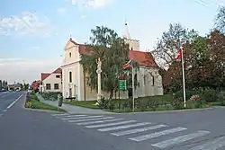
 Church of Saint Margaret | |
.png.webp) Flag  Coat of arms | |
 Chvalovice Location in the Czech Republic | |
| Coordinates: 48°47′12″N 16°4′56″E / 48.78667°N 16.08222°E | |
| Country | |
| Region | South Moravian |
| District | Znojmo |
| First mentioned | 1279 |
| Area | |
| • Total | 8.84 km2 (3.41 sq mi) |
| Elevation | 222 m (728 ft) |
| Population (2023-01-01)[1] | |
| • Total | 684 |
| • Density | 77/km2 (200/sq mi) |
| Time zone | UTC+1 (CET) |
| • Summer (DST) | UTC+2 (CEST) |
| Postal code | 669 02 |
| Website | www |
Chvalovice (German: Kallendorf) is a municipality and village in Znojmo District in the South Moravian Region of the Czech Republic. It has about 700 inhabitants.
Administrative parts
The hamlet of Hatě is an administrative part of Lažánky.
Geography
Chvalovice is located about 7 kilometres (4 mi) southeast of Znojmo and 57 km (35 mi) southwest of Brno. It lies in an agricultural landscape in the Dyje–Svratka Valley. The highest point is at 270 m (890 ft) above sea level.
History
The first written mention of Chvalovice is from 1279. The owners of the village often changed; among the most important were the Dietrichstein family, the Jesuit college in Znojmo and the Cistercian monastery in Tišnov. From the 17th century until 1784, it was property of the Premonstratensian Louka Monastery.[2]
Transport
The I/38 road (part of the European route E59) passes through the municipality.
Chvalovice lies on the border with Austria. There is the road border crossing Hatě / Kleinhaugsdorf.
Sights
The main landmark of Chvalovice is the Church of Saint Margaret. It is a Baroque building with a late Gothic core from the 15th century.[3]
References
- ↑ "Population of Municipalities – 1 January 2023". Czech Statistical Office. 2023-05-23.
- ↑ "Charakteristika obce Chvalovice" (in Czech). Obec Chvalovice. Retrieved 2023-07-03.
- ↑ "Areál kostela sv. Markéty" (in Czech). National Heritage Institute. Retrieved 2023-07-03.