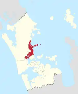
Albany Ward | |
|---|---|
 | |
| Country | New Zealand |
| Island | North Island |
| Region | Auckland Region |
| Area | |
| • Land | 179.81 km2 (69.43 sq mi) |
| Population (June 2023)[2] | |
| • Total | 191,700 |
Albany Ward is an Auckland Council ward which elects two councillors and covers the Hibiscus and Bays and Upper Harbour Local Boards. The two councillors are currently John Watson and Wayne Walker.[3]
Demographics
Albany ward covers 179.81 km2 (69.43 sq mi)[1] and had an estimated population of 191,700 as of June 2023, with a population density of 1,066 people per km2.
| Year | Pop. | ±% p.a. |
|---|---|---|
| 2006 | 124,731 | — |
| 2013 | 143,499 | +2.02% |
| 2018 | 166,854 | +3.06% |
| Source: [4] | ||
Albany ward had a population of 166,854 at the 2018 New Zealand census, an increase of 23,355 people (16.3%) since the 2013 census, and an increase of 42,123 people (33.8%) since the 2006 census. There were 56,415 households, comprising 81,522 males and 85,332 females, giving a sex ratio of 0.96 males per female. The median age was 38.8 years (compared with 37.4 years nationally), with 31,047 people (18.6%) aged under 15 years, 32,538 (19.5%) aged 15 to 29, 77,307 (46.3%) aged 30 to 64, and 25,962 (15.6%) aged 65 or older.
Ethnicities were 71.2% European/Pākehā, 6.0% Māori, 2.2% Pacific peoples, 24.9% Asian, and 3.3% other ethnicities. People may identify with more than one ethnicity.
The percentage of people born overseas was 44.2, compared with 27.1% nationally.
Although some people chose not to answer the census's question about religious affiliation, 52.7% had no religion, 36.0% were Christian, 0.2% had Māori religious beliefs, 1.6% were Hindu, 0.9% were Muslim, 1.4% were Buddhist and 1.6% had other religions.
Of those at least 15 years old, 40,245 (29.6%) people had a bachelor's or higher degree, and 14,676 (10.8%) people had no formal qualifications. The median income was $36,600, compared with $31,800 nationally. 31,788 people (23.4%) earned over $70,000 compared to 17.2% nationally. The employment status of those at least 15 was that 68,169 (50.2%) people were employed full-time, 20,235 (14.9%) were part-time, and 4,149 (3.1%) were unemployed.[4]
Councillors
| Albany Ward councillors of Auckland | |
|---|---|
| Term length | Three years |
| Inaugural holder | Michael Goudie Wayne Walker |
| Formation | 1 November 2010 |
| Website | www.aucklandcouncil.govt.nz |
| Election | Councillors elected | Affiliation | Votes | Notes | |
|---|---|---|---|---|---|
| 2010 | 1 | Michael Goudie | Independent | 9201 | |
| 2 | Wayne Walker | Putting People First | 8547 | ||
| 2013 | 1 | Wayne Walker | Putting People First | 13918 | |
| 2 | John Watson | Putting People First | 12936 | ||
| 2016[5] | 1 | John Watson | Putting People First | 19324[6] | |
| 2 | Wayne Walker | Putting People First | 17938[6] | ||
| 2019 | 1 | John Watson | Putting People First | 28510[7] | |
| 2 | Wayne Walker | Putting People First | 24768[7] | ||
| 2022 | 1 | John Watson | Putting People First | 20575[8] | |
| 2 | Wayne Walker | Putting People First | 20007[8] |
Election Results
Election Results for the Albany Ward:
2022 Election Results
| Name | Affiliation | Votes | |
|---|---|---|---|
| 1 | John Watson | Putting People First | 20575 |
| 2 | Wayne Walker | Putting People First | 20007 |
| Victoria Short | Independent Locals | 14968 | |
| Jake Law | Your Community Future | 9120 | |
| Sylvia Yang | Your Community Future | 7298 | |
| Tony Corbett | Independent | 6529 | |
| Callum Blair | Independent | 6480 | |
| John Davies | Communities First | 3189 | |
| Alezix Heneti | Independent | 1381 | |
| Blank | 3073 | ||
| Informal | 87 | ||
References
- 1 2 "ArcGIS Web Application". statsnz.maps.arcgis.com. Retrieved 24 February 2022.
- ↑ "Subnational population estimates (RC, SA2), by age and sex, at 30 June 1996-2023 (2023 boundaries)". Statistics New Zealand. Retrieved 25 October 2023. (regional councils); "Subnational population estimates (TA, SA2), by age and sex, at 30 June 1996-2023 (2023 boundaries)". Statistics New Zealand. Retrieved 25 October 2023. (territorial authorities); "Subnational population estimates (urban rural), by age and sex, at 30 June 1996-2023 (2023 boundaries)". Statistics New Zealand. Retrieved 25 October 2023. (urban areas)
- ↑ Council, Auckland. "Albany Ward". aucklandcouncil.govt.nz. Archived from the original on 2019-01-24.
- 1 2 "Statistical area 1 dataset for 2018 Census". Statistics New Zealand. March 2020. Albany Ward (07602).
- ↑ "Local body election nominations close". Radio New Zealand. 2016-08-12. Retrieved 5 December 2017.
- 1 2 "Ward councillors – Albany Ward confirmed" (PDF). Auckland Council. 2016. Retrieved 5 December 2017.
- 1 2 "Local board members" (PDF). Auckland Council. 18 October 2019. Retrieved 21 October 2019.
- 1 2 3 "Local Elections 2022 - Official Results" (PDF). Auckland Council. 15 October 2022. Archived (PDF) from the original on 17 October 2022. Retrieved 17 October 2022.