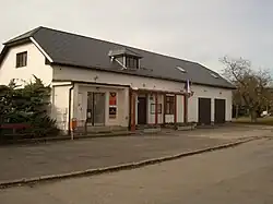
Řitka | |
|---|---|
 Municipal office | |
 Flag  Coat of arms | |
 Řitka Location in the Czech Republic | |
| Coordinates: 49°53′40″N 14°17′58″E / 49.89444°N 14.29944°E | |
| Country | |
| Region | Central Bohemian |
| District | Prague-West |
| First mentioned | 1387 |
| Area | |
| • Total | 3.94 km2 (1.52 sq mi) |
| Elevation | 388 m (1,273 ft) |
| Population (2023-01-01)[1] | |
| • Total | 1,403 |
| • Density | 360/km2 (920/sq mi) |
| Time zone | UTC+1 (CET) |
| • Summer (DST) | UTC+2 (CEST) |
| Postal code | 252 03 |
| Website | www |
Řitka is a municipality and village in Prague-West District in the Central Bohemian Region of the Czech Republic. It has about 1,400 inhabitants.
Geography
Řitka is located about 15 kilometres (9 mi) southwest of Prague. Most of the municipality lies in the Hořovice Uplands, but the northern part lies in the Brdy Highlands. The highest point is at 515 m (1,690 ft) above sea level.
History
The first written mention of Řitka is from 1387.[2]
Transport
The D4 motorway from Prague to Písek runs south of the municipality.
Sights
The only cultural monument in Řitka is the castle. It is a valuable complex of Baroque buildings. A fortress, which was first documented in 1416, was rebuilt into the castle in the mid-17th century.[3] Today the castle complex houses a riding club and there is a training track for eventing.[4]
Notable people
- Wilhelm Weiss (1859–1904), mathematician
- Lata Brandisová (1895–1981), aristocrat and equestrian; lived here
References
- ↑ "Population of Municipalities – 1 January 2023". Czech Statistical Office. 2023-05-23.
- ↑ "O vzniku obce" (in Czech). Obec Řitka. Retrieved 2023-05-31.
- ↑ "Zámek" (in Czech). National Heritage Institute. Retrieved 2023-05-31.
- ↑ "Historie zámku" (in Czech). Řitka Castle. Retrieved 2023-05-31.