Březová-Oleško | |
|---|---|
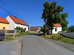
 Hlavní street in Oleško | |
 Flag  Coat of arms | |
 Březová-Oleško Location in the Czech Republic | |
| Coordinates: 49°54′52″N 14°24′59″E / 49.91444°N 14.41639°E | |
| Country | |
| Region | Central Bohemian |
| District | Prague-West |
| First mentioned | 1310 |
| Area | |
| • Total | 6.48 km2 (2.50 sq mi) |
| Elevation | 335 m (1,099 ft) |
| Population (2023-01-01)[1] | |
| • Total | 1,403 |
| • Density | 220/km2 (560/sq mi) |
| Time zone | UTC+1 (CET) |
| • Summer (DST) | UTC+2 (CEST) |
| Postal code | 252 45 |
| Website | www |
Březová-Oleško is a municipality in Prague-West District in the Central Bohemian Region of the Czech Republic. It has about 1,400 inhabitants.
Administrative parts
The municipality is made up of the villages of Březová and Oleško.
Geography
Březová-Oleško is located about 19 kilometres (12 mi) south of Prague. It lies on the Prague Plateau on the right bank of the river Vltava. The municipality is located on a promontory delimited by the valleys of the Vltava and Zahořanský Stream. The highest peak of the municipality is V Hoře at 392 m (1,286 ft) above sea level.
History
The first written mention of both villages is from 1310 (as part of a donation to the Ostrov Monastery, written in a deed of Pope Clement V).[2]
Transport
The municipality can be reached by regular transport from Prague, but it is impassable for cars as it is a dead end.[2]
Sights
There are no cultural monuments.[3]
References
- ↑ "Population of Municipalities – 1 January 2023". Czech Statistical Office. 2023-05-23.
- 1 2 "O obci" (in Czech). Obec Březová-Oleško. Retrieved 2022-05-16.
- ↑ "Výsledky vyhledávání: Kulturní památky, okres Praha-západ". Ústřední seznam kulturních památek (in Czech). National Heritage Institute. Retrieved 2023-05-31.