Åmdals Verk | |
|---|---|
Village | |
 Åmdals Verk Location of the village  Åmdals Verk Åmdals Verk (Norway) | |
| Coordinates: 59°22′34″N 8°02′11″E / 59.37613°N 8.03645°E | |
| Country | Norway |
| Region | Eastern Norway |
| County | Vestfold og Telemark |
| District | Vest-Telemark |
| Municipality | Tokke Municipality |
| Elevation | 425 m (1,394 ft) |
| Time zone | UTC+01:00 (CET) |
| • Summer (DST) | UTC+02:00 (CEST) |
| Post Code | 3882 Åmdals Verk |
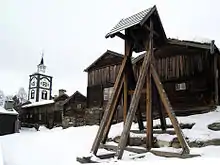
Åmdals Verk is a small village in Tokke Municipality in Vestfold og Telemark county, Norway. The village is located about 8 kilometres (5.0 mi) south of the municipal center of Dalen. The village is the site of a former copper mine. The mines were operational between 1691 and 1945, during which 8,000 tonnes (7,900 long tons; 8,800 short tons) of copper were extracted from the ground. A branch of the Vest-Telemark Museum chronicles the history of the mines, and some of the tunnels are open to the public on guided tours during the summer season.[2][3]
References
- ↑ "Åmdals Verk, Tokke". yr.no. Retrieved 14 January 2023.
- ↑ "Åmdals Verk Mines". Vest-Telemark Museum. Retrieved 9 July 2018.
- ↑ Rui, Ingolf Jarle, ed. (20 December 2020). "Åmdals kobberverk". Store norske leksikon (in Norwegian). Kunnskapsforlaget. Retrieved 14 January 2023.
This article is issued from Wikipedia. The text is licensed under Creative Commons - Attribution - Sharealike. Additional terms may apply for the media files.
