| hrabstwo miejskie | |||
 Merthyr Tydfil | |||
| |||
| Państwo | |||
|---|---|---|---|
| Księstwo | |||
| Siedziba | |||
| Powierzchnia |
111 km² | ||
| Populacja • liczba ludności |
| ||
| • gęstość |
496 os./km² | ||
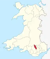
Położenie na mapie Walii | |||
| Strona internetowa | |||
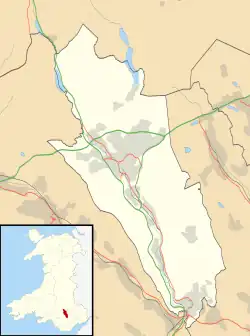
Merthyr Tydfil – hrabstwo miejskie w Walii. Od wschodu graniczy z hrabstwem Caerphilly, od zachodu z Rhondda Cynon Taf a od północy z Powys. W 2011 roku hrabstwo liczyło 58 802 mieszkańców[1][2].
Podział administracyjny
Communities (civil parishes)
- Bedlinog, Cyfarthfa, Dowlais, Gurnos, Merthyr Vale, Pant, Park, Penydarren, Town, Troed-y-Rhiw, Treharris i Vaynor.
Okręgi wyborcze (wards)
- Bedlinog, Cyfarthfa, Dowlais, Gurnos, Merthyr Vale, Park, Penydarren, Plymouth, Town, Treharris i Vaynor[3].
Miejscowości

Miejscowości w Merthyr Tydfil
Na terenie hrabstwa znajdują się następujące miejscowości[4][5] (w nawiasach liczba ludności w 2011[6]):
- Merthyr Tydfil (43 820)
- Treharris (7705)
- Aberfan (3547)
- Bedlinog (1112)
- Trefechan (1042)
Przypisy
- ↑ Area: Merthyr Tydfil (Local Authority). Neighbourhood Statistics (ONS). [dostęp 2016-10-29]. [zarchiwizowane z tego adresu (2016-10-29)]. (ang.).
- ↑ Merthyr Tydfil, [w:] Encyclopædia Britannica [dostęp 2016-10-29] (ang.).
- ↑ Merthyr Tudful - Merthyr Tydfil. Ordnance Survey linked data. [dostęp 2016-10-29]. (ang.).
- ↑ Office for National Statistics: Built-up Area to Local Authority District (December 2011) Lookup in England and Wales. [w:] Open Geography Portal [on-line]. [dostęp 2022-06-05]. (ang.).
- ↑ Office for National Statistics: Built-up Area Sub Divisions (December 2011) Boundaries. [w:] Open Geography Potal [on-line]. [dostęp 2022-06-05]. (ang.).
- ↑ Office for National Statistics: KS101EW - Usual resident population. [w:] 2011 Census [on-line]. Nomis – Official labour market statistics, 2013-02-12. [dostęp 2022-06-05]. (ang.).
This article is issued from Wikipedia. The text is licensed under Creative Commons - Attribution - Sharealike. Additional terms may apply for the media files.
