| London Borough of | |||
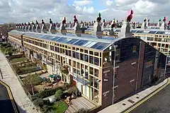
 BedZED ekologiczne osiedle | |||
| |||
| Państwo | |||
|---|---|---|---|
| Kraj | |||
| Region | |||
| Burmistrz |
Jean Crossby | ||
| Powierzchnia |
43,85 km² | ||
| Populacja (2016) • liczba ludności |
| ||
| • gęstość |
4612 os./km² | ||
| Kod pocztowy |
KT4, KT17, SM1, SM2, SM3, SM4, SM5, SM8, SM7, CR0, CR4, CR5, CR8 | ||
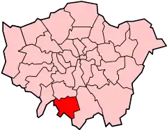
Położenie na mapie Wielkiego Londynu | |||
| Strona internetowa | |||


London Borough of Sutton – jedna z 32 gmin Wielkiego Londynu położona w jego południowej części. Wraz z 19 innymi gminami wchodzi w skład tzw. Londynu Zewnętrznego. Władzę stanowi Rada Gminy Sutton (ang. Sutton Council).
Historia
Gminę utworzono w 1965 roku na podstawie ustawy London Government Act 1963[2] z obszarów Sutton and Cheam (ang. Municipal Borough of Sutton and Cheam)[3] utworzonego w 1934 roku, Beddington and Wallington (ang. Municipal Borough of Beddington and Wallington) utworzonego w 1937 roku[4] oraz Carshalton (ang. Carshalton Urban District) utworzonego w 1894 roku[5].
Geografia
Gmina Sutton ma powierzchnię 43,85 km², graniczy od północy z Merton, od zachodu z Kingston upon Thames, od wschodu z Croydon, zaś od południa kolejno z dystryktami Epsom and Ewell i Reigate and Banstead w hrabstwie Surrey.
W skład gminy Sutton wchodzą następujące obszary:
|
|
Gmina dzieli się na 18 okręgów wyborczych[6] które nie pokrywają się dokładnie z podziałem na obszary, zaś mieszczą się w dwóch rejonach tzw. borough constituencies – Carshalton and Wallington i Sutton and Cheam[7].
|
|
Demografia
W 2011 roku gmina Sutton miała 190 146 mieszkańców[8].
Podział mieszkańców według grup etnicznych na podstawie spisu powszechnego z 2011 roku[9]:
|
|
Podział mieszkańców według wyznania na podstawie spisu powszechnego z 2011 roku[10]:
- Chrześcijaństwo - 58,4%
- Islam – 4,1%
- Hinduizm – 4,2%
- Judaizm – 0,3%
- Buddyzm – 0,7%
- Sikhizm – 0,2%
- Pozostałe religie – 0,4%
- Bez religii – 24,6%
- Nie podana religia – 7,1%
Podział mieszkańców według miejsca urodzenia na podstawie spisu powszechnego z 2011 roku[11]:
|
|
Transport

Sutton jest jedną z sześciu londyńskich gmin przez którą nie przebiega ani jedna linia metra.
Pasażerskie połączenia kolejowe na terenie Sutton obsługują przewoźnicy: First Capital Connect, South West Trains i Southern.
Stacje kolejowe:
- Belmont
- Carshalton
- Carshalton Beeches
- Cheam
- Hackbridge
- Sutton
- Sutton Common
- Wallington
- West Sutton
- Worcester Park (na granicy z Kingston upon Thames)
Na terenie gminy Sutton działa system komunikacji tramwajowej Tramlink.
Przystanki tramwajowe:
Miejsca i muzea

Edukacja

- Carshalton College[22]
- Sutton College of Learning for Adults[23]
- Carshalton Boys Sports College[24]
- Carshalton High School for Girls[25]
- Cheam High School[26]
- Glenthorne High School[27]
- Greenshaw High School[28]
- Nonsuch High School for Girls[29]
- Overton Grange School[30]
- St. Philomena's Catholic High School for Girls[31]
- Stanley Park High School[32]
- Sutton Grammar School for Boys[33]
- John Fisher School[34]
- Wallington County Grammar School for Boys[35]
- Wallington High School for Girls[36]
- Wilson's School[37]
Znane osoby
W Sutton urodzili się m.in.
- John Major – polityk
- Harry Aikines-Aryeetey – lekkoatleta
- Paul Greengrass – scenarzysta i reżyser
- Tony Barton – piłkarz i trener piłkarski
- Jeff Beck – gitarzysta rockowy
- James Hunt – kierowca wyścigowy
- Quentin Crisp – pisarz i aktor
- Joanna Rowsell – kolarka szosowa i torowa
- Neil Sullivan – piłkarz
- Peter Manley – darter
- Rebecca Romero – wioślarka i kolarka torowa
- Phyllis King – tenisistka
Przypisy
- ↑ Population Estimates for UK, England and Wales, Scotland and Northern Ireland - Office for National Statistics [online], www.ons.gov.uk [dostęp 2017-10-16] (ang.).
- ↑ „ Legislation.gov.uk- London Government Act 1963”
- ↑ „visionofbritain.org.uk - unit history of Sutton and Cheam”
- ↑ „visionofbritain.org.uk - unit history of Beddington and Wallington”
- ↑ „visionofbritain.org.uk - unit history of Carshalton”. [dostęp 2012-01-07]. [zarchiwizowane z tego adresu (2007-10-01)].
- ↑ „sutton.moderngov.co.uk – Election results by wards”
- ↑ „ukpollingreport.co.uk-london”
- ↑ „ons.gov.uk – 2011 Census: KS102EW Age structure, local authorities in England and Wales”
- ↑ „ons.gov.uk – 2011 Census: KS201EW Ethnic group, local authorities in England and Wales”
- ↑ „ons.gov.uk – 2011 Census: KS209EW Religion, local authorities in England and Wales”
- ↑ „ons.gov.uk – 2011 Census: KS204EW Country of birth, local authorities in England and Wales”
- ↑ „sutton.gov.uk - Honeywood Museum”
- ↑ „sutton.gov.uk - Little Holland House”
- ↑ „sutton.gov.uk - Whitehall”
- ↑ „sutton.gov.uk - Carew Manor”
- ↑ „secombetheatre.co.uk - Secombe Theatre”. [dostęp 2012-01-07]. [zarchiwizowane z tego adresu (2012-01-17)].
- ↑ „secombetheatre.co.uk - Charles Cryer Studio Theatre”. [dostęp 2012-01-07]. [zarchiwizowane z tego adresu (2012-01-17)].
- ↑ Bartosz Palewski: BedZED – ekologiczne osiedle Londynu. architekturakrajobrazu.info, 21 grudnia 2011. [dostęp 2013-02-01]. [zarchiwizowane z tego adresu (13 lutego 2013)]. (pol.).
- ↑ „theoaksgolf.co.uk - Oaks Golf Club”
- ↑ „cuddingtongc.co.uk - Cuddington Golf Club”
- ↑ „woodcotepgc.com - Woodcote Park Golf Club”
- ↑ „carshalton.ac.uk - Carshalton College”
- ↑ „scola.ac.uk - Sutton College of Learning for Adults”. [dostęp 2012-01-07]. [zarchiwizowane z tego adresu (2012-01-20)].
- ↑ „carshaltonboys.org - Carshalton Boys Sports College ”
- ↑ „chsg.org.uk - Carshalton High School for Girls”
- ↑ „cheam.sutton.sch.uk - Cheam High School”
- ↑ „glenthorne.sutton.sch.uk - Glenthorne High School”
- ↑ „greenshaw.co.uk - Greenshaw High School”
- ↑ „nonsuch.co.uk - Nonsuch High School for Girls”. [dostęp 2012-01-07]. [zarchiwizowane z tego adresu (2012-02-17)].
- ↑ „overtongrange.sutton.sch.uk - Overton Grange School”
- ↑ „stphils.org.uk - St. Philomena's Catholic High School for Girls”
- ↑ „stanleyparkhigh.org.uk - Stanley Park High School”
- ↑ „suttongrammar.sutton.sch.uk - Sutton Grammar School for Boys”
- ↑ „johnfisher.sutton.sch.uk - The John Fisher School”. [dostęp 2012-01-07]. [zarchiwizowane z tego adresu (2012-03-04)].
- ↑ „wcgs.org.uk - Wallington County Grammar School for Boys”
- ↑ „wallingtongirls.sutton.sch.uk - Wallington High School for Girls”
- ↑ „wilsonsschool.sutton.sch.uk - Wilson's School”. [dostęp 2012-01-07]. [zarchiwizowane z tego adresu (2019-02-20)].
