| hrabstwo | |
 | |
| Państwo | |
|---|---|
| Stan | |
| Siedziba | |
| Kod statystyczny |
FIPS 6-4: 23019 |
| Powierzchnia |
9210 km² |
| Populacja (2010) • liczba ludności |
|
| • gęstość |
43 os./km² |
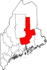
Położenie na mapie Maine | |
| 45°23′58″N 68°37′44″W/45,399444 -68,628889 | |
| Strona internetowa | |
Hrabstwo Penobscot (Penobscot County) – hrabstwo we wschodniej części amerykańskiego stanu Maine. Zajmuje powierzchnię 9210 km² i liczy 153 923 mieszkańców (2010)[1]. Ośrodkiem administracyjnym hrabstwa jest Bangor. Powstało w 1816 roku.
Miasta
- Alton
- Bangor
- Brewer
- Bradford
- Bradley
- Burlington
- Carmel
- Charleston
- Chester
- Clifton
- Corinna
- Corinth
- Dexter
- Dixmont
- East Millinocket
- Eddington
- Edinburg
- Enfield
- Etna
- Exeter
- Garland
- Glenburn
- Greenbush
- Hampden
- Hermon
- Holden
- Howland
- Hudson
- Kenduskeag
- Lakeville
- Lee
- Levant
- Lincoln
- Lowell
- Mattawamkeag
- Maxfield
- Medway
- Milford
- Millinocket
- Mount Chase
- Newburgh
- Newport
- Orono
- Old Town
- Orrington
- Passadumkeag
- Patten
- Plymouth
- Springfield
- Stacyville
- Stetson
- Veazie
- Winn
- Woodville
CDP
Przypisy
- ↑ Penobscot County, Maine – Population Finder – American FactFinder. [dostęp 2013-04-07].
This article is issued from Wikipedia. The text is licensed under Creative Commons - Attribution - Sharealike. Additional terms may apply for the media files.
