| gmina | |||||
 | |||||
| Państwo | |||||
|---|---|---|---|---|---|
| Dystrykt | |||||
| Kraina historyczna |
Beira Alta | ||||
| Region (NUTS 2) | |||||
| Podregion (NUTS 3) |
Serra da Estrela | ||||
| Powierzchnia |
302,49 km² | ||||
| Populacja (2011) • liczba ludności |
| ||||
| • gęstość |
46,43 os./km² | ||||
| Szczegółowy podział administracyjny | |||||
| Liczba sołectw |
22 | ||||
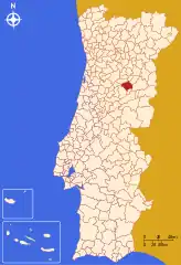
Położenie na mapie Portugalii | |||||
| 40°30′N 7°36′W/40,500000 -7,600000 | |||||
| Strona internetowa | |||||
Gouveia – miejscowość w Portugalii, leżąca w dystrykcie Guarda, w regionie Centrum w podregionie Serra da Estrela. Miejscowość jest siedzibą gminy o tej samej nazwie.
Demografia
| Liczba ludności gminy Gouveia (1801–2011) | |||||||||
|---|---|---|---|---|---|---|---|---|---|
| 1801 | 1849 | 1900 | 1930 | 1960 | 1981 | 1991 | 2001 | 2004 | 2011 |
| 7 051 | 14 162 | 24 641 | 23 724 | 25 210 | 19 045 | 17 410 | 16 122 | 15 792 | 14 046[1] |
Sołectwa
Sołectwa gminy Gouveia (ludność wg stanu na 2011 r.):[1]
- Aldeias – 328 osób
- Arcozelo – 717 osób
- Cativelos – 724 osoby
- Figueiró da Serra – 263 osoby
- Folgosinho – 499 osób
- Freixo da Serra – 99 osób
- Lagarinhos – 443 osoby
- Mangualde da Serra – 164 osoby
- Melo – 498 osób
- Moimenta da Serra – 652 osoby
- Nabais – 405 osób
- Nespereira – 758 osób
- Paços da Serra – 601 osób
- Ribamondego – 317 osób
- Rio Torto – 463 osoby
- São Julião – 1622 osoby
- São Paio – 828 osób
- São Pedro – 1850 osób
- Vila Cortês da Serra – 267 osób
- Vila Franca da Serra – 262 osoby
- Vila Nova de Tazem – 1708 osób
- Vinhó – 578 osób
Przypisy
- 1 2 3 Statistics Portugal [online], www.ine.pt [dostęp 2018-02-11] (ang.).
This article is issued from Wikipedia. The text is licensed under Creative Commons - Attribution - Sharealike. Additional terms may apply for the media files.

