Zvěstov | |
|---|---|
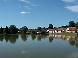
 Návesní Pond in the centre of Zvěstov | |
 Flag  Coat of arms | |
 Zvěstov Location in the Czech Republic | |
| Coordinates: 49°37′58″N 14°47′32″E / 49.63278°N 14.79222°E | |
| Country | |
| Region | Central Bohemian |
| District | Benešov |
| First mentioned | 1383 |
| Area | |
| • Total | 22.39 km2 (8.64 sq mi) |
| Elevation | 410 m (1,350 ft) |
| Population (2023-01-01)[1] | |
| • Total | 394 |
| • Density | 18/km2 (46/sq mi) |
| Time zone | UTC+1 (CET) |
| • Summer (DST) | UTC+2 (CEST) |
| Postal code | 257 06 |
| Website | www |
Zvěstov is a municipality and village in Benešov District in the Central Bohemian Region of the Czech Republic. It has about 400 inhabitants.
Administrative parts
Villages and hamlets of Bořkovice, Hlohov, Laby, Libouň, Ondřejovec, Otradov, Roudný, Šlapánov, Vestec and Vlastišov are administrative parts of Zvěstov.
Etymology
The name is derived from the personal name Zvěst.[2]
Geography
Zvěstov is located about 18 kilometres (11 mi) southeast of Benešov and 49 km (30 mi) southeast of Prague. It lies in the Vlašim Uplands. The highest point is the hill Vinná hora at 543 m (1,781 ft) above sea level.
History
The first written mention of Zvěstov is from 1383. Existence of the local fortress was first documented in 1443.[2]
Sights
The most important monument is the Church of Saint Wenceslaus in Libouň. It is a small church with a Romanesque rotunda from the first half of the 13th century.[3]
The old fortress was rebuilt into a Renaissance castle in the late 16th century. Part of the Renaissance sgraffito on the façade has been preserved. Today the castle is dilapidated and unused.[2]
References
- ↑ "Population of Municipalities – 1 January 2023". Czech Statistical Office. 2023-05-23.
- 1 2 3 "Historie obce" (in Czech). Obec Zvěstov. Retrieved 2023-04-14.
- ↑ "Kostel sv. Václava" (in Czech). National Heritage Institute. Retrieved 2023-04-14.