Zurmi | |
|---|---|
LGA and town | |
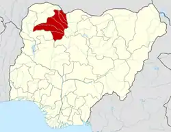
 Zurmi Location in Nigeria | |
| Coordinates: 12°51′N 6°44′E / 12.850°N 6.733°E | |
| Country | |
| State | Zamfara State |
| Area | |
| • Total | 2,834 km2 (1,094 sq mi) |
| Population (2006 census) | |
| • Total | 293,837 |
| Time zone | UTC+1 (WAT) |
| 3-digit postal code prefix | 882 |
| ISO 3166 code | NG.ZA.ZU |
Zurmi is a Local Government Area in Zamfara State, Nigeria. Its headquarters is in the town of Zurmi at 12°46′00″N 6°47′10″E / 12.76667°N 6.78611°E.
It has an area of 2,834 km2 and a population of 293,837 at the 2006 census.
The postal code of the area is 882.[1] it shares border with Niger republic from the North and Katsina state from East its end stop at the most populated village Gurbin Bore under Kwashabawa ward after Crossed the inter-state Bridge constructed in the early 1990, 4 years after the establishment of the Whole state in 1996.
Flooding
An official reported on Friday that the flood calamity that struck Zamfara State on Wednesday damaged 110 homes in the local government area of Zurmi.[2]
The Nigerian Metrological Agency (NiMet) has identified seven Local Givernment Areas in the state that it expects to flood during the 2020 rainy season, including Zurmi.[3]
Climate
The temperature ranges from 59°F to 102°F year-round and is oppressively hot, cloudy, and windy during the dry season.[4]
References
- ↑ "Post Offices- with map of LGA". NIPOST. Archived from the original on October 7, 2009. Retrieved 2009-10-20.
- ↑ "Flood destroys 110 houses in Zamfara". EnviroNews Nigeria. 2020-08-07. Retrieved 2023-10-01.
- ↑ "Zamfara banditry victims touched by floods - Daily Trust". dailytrust.com. Retrieved 2023-09-29.
- ↑ "Zurmi Climate, Weather By Month, Average Temperature (Nigeria) - Weather Spark". weatherspark.com. Retrieved 2023-09-01.
