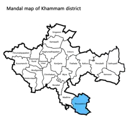
Yerrupalem mandal | |
|---|---|
Mandal | |
 Yerrupalem mandal highlighted in blue | |
 Yerrupalem mandal Location in Telangana, India | |
| Coordinates: 16°50′00″N 80°28′00″E / 16.8333°N 80.4667°E | |
| Country | India |
| State | Telangana |
| District | Khammam |
| Headquarters | Yerrupalem |
| Population (2011) | |
| • Total | 49,851 |
| Languages | |
| • Official | Telugu |
| Time zone | UTC+5:30 (IST) |
Yerrupalem mandal[1] is one of the 21 mandals[2] (administrative divisions) located in the Khammam district of Telangana, India. It falls under the jurisdiction of the Khammam revenue division, with its headquarters situated in the village of Yerrupalem.[3]
Demographics
According to 2011 Census of India, Yerrupalem mandal has a population of 49,851, with 25,078 males and 24,773 females. The sub-district has 4,537 children, 14,095 individuals from Scheduled Castes, and 1,685 individuals from Scheduled Tribes. The literacy rate is 27,950, while the illiterate population is 21,901. There are 28,146 workers and 21,705 non-workers in the area.[4]
Villages in Yerrupalem mandal
- Ayyavarigudem
- Banigandlapadu
- Bheemavaram
- Choppakatlapalem
- Gatla Gowraram
- Gosaveedu
- Guntupalle Gopavaram
- Inagali
- Jamalapuram
- Kacharam
- Kesireddipalle
- Mamunuru
- Meenavole
- Mulugumadu
- Pedda Goparam
- Pegallapadu
- Rajulapalem
- Rangagudem
- Remidicherla
- Sakhina Veedu
- Tatigudem
- Thakkellapadu
- Tripuraram
- Yerrupalem - Mandal headquarters
References
- ↑ "Zilla Praja Parishad, Khammam | Khammam District | India". Retrieved 2023-06-03.
- ↑ "::Telangana State Development Planning Society::". www.tsdps.telangana.gov.in. Retrieved 2023-06-03.
- ↑ "Telangana State Police". www.tspolice.gov.in. Retrieved 2023-06-03.
- ↑ "Visualizations | Government of India". censusindia.gov.in. Retrieved 2023-06-03.
This article is issued from Wikipedia. The text is licensed under Creative Commons - Attribution - Sharealike. Additional terms may apply for the media files.