Whoopflarea | |
|---|---|
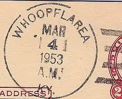
 Postmark from Whoopflarea, Kentucky | |
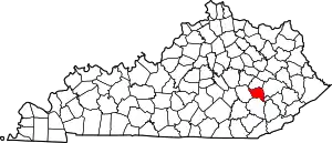
 Whoopflarea Location within the state of Kentucky  Whoopflarea Whoopflarea (the United States) | |
| Coordinates: 37°17′52″N 83°34′5″W / 37.29778°N 83.56806°W | |
| Country | United States |
| State | Kentucky |
| County | Owsley |
| Elevation | 971 ft (296 m) |
| Time zone | UTC-5 (Eastern (EST)) |
| • Summer (DST) | UTC-4 (EDT) |
| GNIS feature ID | 516350[1] |
Whoopflarea is an unincorporated community located in Owsley County, Kentucky, United States. Its post office closed in April 1954.[2] Whoopflarea has been noted for its unusual place name.[3]
The town name has several proposed origins. The most accepted is the whoop of owls made in the remote area. Other suggested origins include a search for lost persons in the area' according to this etymology, the community's name comes from the fact that searchers literally "whooped" for someone called Larry or Laura.[4]
References
- ↑ U.S. Geological Survey Geographic Names Information System: Whoopflarea, Kentucky
- ↑ "Postmaster Finder - Who We Are - USPS". About.usps.com. Retrieved February 24, 2020.
- ↑ Strecker, Zoe; Finch, Jackie Sheckler (July 1, 2009). Kentucky Off the Beaten Path. Rowman & Littlefield. p. 11. ISBN 978-0-7627-5790-9.
- ↑ Rennick, Charles (1984). Kentucky Place Names. Lexington, KY: University Press of Kentucky. p. 318.
This article is issued from Wikipedia. The text is licensed under Creative Commons - Attribution - Sharealike. Additional terms may apply for the media files.
