| White River | |
|---|---|
 | |
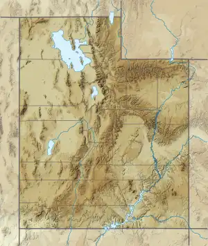
 Location of mouth of the White River | |
| Location | |
| Country | United States |
| State | Utah |
| Region | Wasatch County, Utah and Utah County, Utah Counties |
| Cities | Soldier Summit, Colton |
| Physical characteristics | |
| Source | |
| • location | Confluence of Left Fork White River and Right Fork White River, east of Soldier Summit, Utah |
| • coordinates | 39°55′25″N 111°03′25″W / 39.92365°N 111.05689°W |
| • elevation | 7,362 ft (2,244 m) |
| Mouth | Confluence with the Price River |
• location | Colton, Utah |
• coordinates | 39°50′19″N 111°00′24″W / 39.83856°N 111.00670°W |
• elevation | 7,162 ft (2,183 m) |
| Basin features | |
| Tributaries | |
| • left | Tabbyune Creek |
| • right | Left Fork White River |
The White River is a 8-mile-long (13 km)[1] southeastward flowing river in Wasatch and Utah Counties in eastern Utah. The White River is a tributary to the Price River, which is, in turn, a tributary to the Green River, and then to the Colorado River.
History
In pioneer times, northbound travelers from the Castle or Price River Valleys ascended along the White River to the Emma and Whitmore Park area east of Soldier Summit and then descended northeast through the Soldier Creek canyon to reach the cities of the Utah and Salt Lake Valleys.[2]
Watershed and Course
About 6 miles (9.7 km) northeast of Soldier Summit, the White River mainstem is formed by the confluence of the Left Fork White River,[3] which begins on the south flank of Willow Creek Ridge, and the Right Fork White River[4] which drains Reservation Ridge.[5] Most of the upper watershed is in Wasatch County in the Uinta National Forest, now part of the Wasatch-Cache National Forest. The Left Fork also has a Middle Fork White River tributary. As the White River heads southeast along U.S. Route 6, it is joined by Tabbyune Creek,[6] before ending at the confluence with the Price River in Colton in Utah County.
Ecology
The White River, and other headwater streams of the Price River, harbor Colorado River cutthroat trout ((Oncorhynchus clarki pleuriticus). The distribution and abundance of this cutthroat trout subspecies are now limited to small populations in less than 1% of its historic range in the upper tributaries of the Colorado River watershed. The chief vulnerability of Colorado River cutthroat trout is hybridization with non-native rainbow trout and competitive replacement by non-native brown trout (Salmo trutta) and brook trout (Salvelinus fontinalis).[7] Other fish found in the White River watershed include mottled sculpin (Cottus bairdii), speckled dace (Rhinichthys osculus), and mountain sucker (Catostomus platyrhynchus).[8]
See also
References
- ↑ U.S. Geological Survey. National Hydrography Dataset high-resolution flowline data. The National Map, accessed November 1, 2020
- ↑ Ronald G. Watt (1997). A History of Carbon County. Utah State Historical Society Carbon County Commission. p. 11.
- ↑ U.S. Geological Survey Geographic Names Information System: Left Fork White River
- ↑ U.S. Geological Survey Geographic Names Information System: Right Fork White River
- ↑ John W. Van Cott (1990). Utah Place Names: A Comprehensive Guide to the Origins of Geographic Names: a Compilation. University of Utah Press. p. 397. ISBN 978-0-87480-345-7.
- ↑ U.S. Geological Survey Geographic Names Information System: Tabbyune Creek
- ↑ Richard A. Valdez; Robert T. Muth (2005). "Ecology and Conservation of Native Fish in the Upper Colorado River Basin". American Fisheries Society Symposium. 45: 157–204. Retrieved October 30, 2020.
- ↑ Paul K. Cowley (January 22, 1996). Fiish Surveys on the Uinta & Wasatch-Cache National Forests 1995 (PDF) (Report). United States Forest Service. p. 55. Retrieved November 1, 2020.