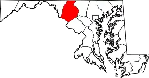
Utica, Maryland | |
|---|---|
Unincorporated community | |
 Utica Location in Maryland | |
| Coordinates: 39°31′34″N 77°23′38″W / 39.52611°N 77.39389°W | |
| Country | United States |
| State | Maryland |
| County | Frederick County |
| Time zone | UTC-5 (Eastern) |
| • Summer (DST) | UTC-4 (EDT) |
| Area code | 410 and 443 |
Utica, also known as Utica Mills, is an unincorporated community located in Frederick County, Maryland, United States, at the intersection of Old Frederick Road and Lenhart Road.[1][2]
It is home to St. Paul's Evangelical Lutheran Church.[3]
The Utica Covered Bridge, also known as the Utica Mills Covered Bridge, is located nearby.[4]
History
During the Civil War, the 18th Regiment Massachusetts Volunteer Infantry arrived at the outskirts of Utica on Tuesday, July 7, 1863.[5]
Dr. George F. Smith, one of the first druggists to serve Coca-Cola, and founder of the Rosebud Perfume Company in Woodsboro, Maryland, taught school in Utica for five years, before becoming a druggist in 1902.[6][7]
References
- ↑ "Utica (in Frederick County, MD) Populated Place Profile". MD Home Town Locator. Retrieved June 16, 2014.
- ↑ "Feature Detail Report for Utica". USGS Geographic Names Information System. U.S. Department of the Interior. Retrieved June 16, 2014.
- ↑ "St. Paul's Evangelical Lutheran Church, Frederick Co., MD". USGenWeb Tombstone Project. Retrieved 2014-06-14.
- ↑ "Utica Mills Covered Bridge by Joan Carroll - Utica Mills Covered Bridge Photograph". Pixels.com. Retrieved 2014-06-14.
- ↑ "The Pursuit - Tuesday, July 7, 1863". Touch the Elbow - Blogging the Civil War. Retrieved 2014-06-14.
- ↑ "History". Rosebud Perfume Co. Retrieved 2014-06-14.
- ↑ "Aerial Photography Map of Utica, MD Maryland Latitude: 39.525934 , Longitude: -77.393874". www.landsat.com. Retrieved 2014-06-14.
This article is issued from Wikipedia. The text is licensed under Creative Commons - Attribution - Sharealike. Additional terms may apply for the media files.
