Untersiemau | |
|---|---|
 Castle in the town | |
 Coat of arms | |
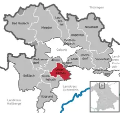
Location of Untersiemau within Coburg district  | |
 Untersiemau  Untersiemau | |
| Coordinates: 50°11′39″N 10°58′23″E / 50.19417°N 10.97306°E | |
| Country | Germany |
| State | Bavaria |
| Admin. region | Oberfranken |
| District | Coburg |
| Government | |
| • Mayor (2020–26) | Rolf Rosenbauer[1] (CSU) |
| Area | |
| • Total | 20.49 km2 (7.91 sq mi) |
| Elevation | 299 m (981 ft) |
| Population (2022-12-31)[2] | |
| • Total | 4,215 |
| • Density | 210/km2 (530/sq mi) |
| Time zone | UTC+01:00 (CET) |
| • Summer (DST) | UTC+02:00 (CEST) |
| Postal codes | 96253 |
| Dialling codes | 09565 |
| Vehicle registration | CO |
| Website | www.untersiemau.de |
Untersiemau is a municipality in the district of Coburg in Bavaria in Germany.
Geography
Location
Untersiemau lies about 10 kilometres (6.2 miles) south of Coburg at the eastern edge of Itz Valley.
Subdivisions
Untersiemau is divided into 9 Ortsteile:
- Birkach am Forst
- Haarth
- Meschenbach
- Obersiemau
- Scherneck
- Stöppach
- Untersiemau
- Weißenbrunn am Forst
- Ziegelsdorf
History
Untersiemau was first mentioned about 800 as Suome, the name is of Slavic origin.[3]
Transport
Untersiemau can be reached by car via motorway A 73 Suhl-Coburg-Nuremberg. Untersiemau used to have a station at the Itz Valley Railway, which was lifted in 2005.
References
- ↑ Liste der ersten Bürgermeister/Oberbürgermeister in kreisangehörigen Gemeinden, Bayerisches Landesamt für Statistik, 15 July 2021.
- ↑ Genesis Online-Datenbank des Bayerischen Landesamtes für Statistik Tabelle 12411-003r Fortschreibung des Bevölkerungsstandes: Gemeinden, Stichtag (Einwohnerzahlen auf Grundlage des Zensus 2011)
- ↑ Debus, Arno. 1200 Jahre Untersiemau (in German).
This article is issued from Wikipedia. The text is licensed under Creative Commons - Attribution - Sharealike. Additional terms may apply for the media files.