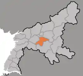
Ŭnsan County
은산군 | |
|---|---|
| Korean transcription(s) | |
| • Chosŏn'gŭl | 은산군 |
| • Hancha | 殷山郡 |
| • McCune-Reischauer | Ŭnsan-gun |
| • Revised Romanization | Eunsan-gun |
 Map of South Pyongan showing the location of Unsan | |
| Country | North Korea |
| Province | South P'yŏngan |
| Administrative divisions | 1 ŭp, 5 workers' districts, 16 ri |
Ŭnsan County is a kun (county) in South P'yŏngan province, North Korea.[1]
Name
The name Unsan is proposed to have been derived from either the Chinese character 银 or 隐, both read as "un" in Korean, referring to the possibility of silver being mined in a mine located in Sinchang, or 'hidden', as the area is surrounded by mountains, such as Hwasan. However, in historical records, only the word 殷 has been recorded as a name.[2]
History
Hungdok-gun, the predecessor to the current administrative division, was formed in the early Goguryeo period from Sunchon-gun. This later became Unju in 983 and subsequently Unsan-hyon in 1278. In 1414, after the establishment of the Joseon, it was briefly absorbed into Chasan-gun, then reestablished in 1415. In 1895, the myon was reorganised into a gun and subsequently was changed into a hyon in 1896. It was again absorbed into Sunchon-gun in 1907 and restablished in 1952.[2]
In 1954, the original Unsan-up and Suwon-ri were merged and renamed to Sinchang-ri, while parts of Jinsan-ri and Sonam-ri became the new Unsan-up.[2]
In 1974, several dongs were promoted to rodongjagu amongst a large scale reorganisation of districts, with some districts joining Sunchon.[2]
In 1994, Sinpyong-ri was transferred to Pukchang County.[2]
By the 1990s, Kubong-rodongjagu had been developed into a large mining town, with over 4600 residences and various services, such as hospitals, culture halls and schools.[3]
Administrative divisions
Ŭnsan county is divided into 1 ŭp (town), 5 rodongjagu (workers' districts) and 16 ri (villages):
|
|
Transportation
Ŭnsan County is served by the P'yŏngra and Ŭnsan lines of the Korean State Railway.
A trolleybuses existed in Kubong-rodongjagu, serving the Ryongdae Mine. This line had a stated length of 10-ri with 4 stops, connecting the workers' district to the entrance 2nd pit of Ryongdae Mine. Services run 24 hours a day, 7 days a week.[3]
References
