Ulen Historic District | |
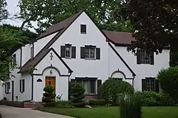
 113 Ulen Boulevard, June 2016 | |
   | |
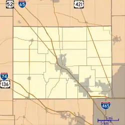
| Location | Roughly Ulen Country Club and Golf Course, and houses along Ulen Boulevard and East Dr., Ulen, Indiana |
|---|---|
| Coordinates | 40°03′48″N 86°27′49″W / 40.06333°N 86.46361°W |
| Area | 146 acres (59 ha) |
| Built by | Ulen, Henry C. |
| Architect | Pierre & Wright; Cook, Oscar; Donaldson & Co.; Pfeiffer, R. J.; Diddel, William (Bill) |
| Architectural style | Colonial Revival, Tudor Revival, Mediterranean Revival, Ranch Style |
| MPS | Historic Residential Suburbs in the United States, 1830-1960 MPS |
| NRHP reference No. | 15000591[1] |
| Added to NRHP | September 16, 2015 |
Ulen Historic District, also known as Country Club Addition, is a national historic district located at Ulen, Boone County, Indiana. The district encompasses 53 contributing buildings, 2 contributing sites, 1 contributing structure, and 4 contributing objects in an upscale suburban area near Indianapolis and next to the Ulen Country Club and golf course. The golf course was the first designed by Bill Diddel. The district developed between about 1924 and 1963, and includes representative examples of Colonial Revival, Tudor Revival, Mediterranean Revival, and Ranch Style architecture.[2]
It was listed on the National Register of Historic Places in 2015.[1]
References
- 1 2 "National Register of Historic Places Listings". Weekly List of Actions Taken on Properties: 9/14/15 through 9/18/15. National Park Service. September 25, 2015.
- ↑ "Indiana State Historic Architectural and Archaeological Research Database (SHAARD)" (Searchable database). Department of Natural Resources, Division of Historic Preservation and Archaeology. Retrieved September 1, 2016. Note: This includes Connie Zeigler (February 2015). "National Register of Historic Places Inventory Nomination Form: Ulen Historic District" (PDF). Retrieved September 1, 2016., Site map, and Accompanying photographs.
Wikimedia Commons has media related to Ulen Historic District.
This article is issued from Wikipedia. The text is licensed under Creative Commons - Attribution - Sharealike. Additional terms may apply for the media files.

