Ulaankhus District
Улаанхус сум ᠤᠯᠠᠭᠠᠩᠬᠤᠰᠤᠰᠤᠮᠤ | |
|---|---|
 | |
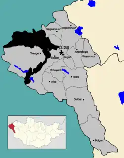
 Location of Ulaankhus in Bayan-Ölgii Province (highlighted in black within the light grey area, which in turn is highlighted red within Mongolia in the window.) | |
| Country | |
| Province | Bayan-Ölgii Province |
| Area | |
| • Total | 6,047.93 km2 (2,335.12 sq mi) |
| Population (2014) | |
| • Total | 8,010 |
| Time zone | UTC+7 (UTC + 7) |
Ulaankhus (Mongolian: Улаанхус, Red birch) is a sum (district) of Bayan-Ölgii Province in western Mongolia. The seat of the district is Bilüü, situated 46 kilometres (29 mi) west of the city of Ölgii and 1,682 kilometres (1,045 mi) from the Mongolian capital of Ulan Bator. It is primarily inhabited by ethnic Kazakhs. As of 2014 it had a population of 8010 people.[1]
History
Historically, Ulaankhus was settled by Kazakhs who moved to the northern side of the Altai Mountains. In 1922, Sherushy khoshuun with the canter in Akbalshyk, currently Bilüü, was established. In 1922, it was split into Sherushy and Shebaraigyr, and in 1925 into Sherushy, Shebaraigyr, Botakara, and Zhantekey. These khoshuuns belonged to Khovd Province. In 1938, Sherushy khoshuun was renamed Ulaankhus sum. In 1940, Bayan-Ölgii Province was established, and the sum was subordinated to this province.[2]
Geography
Ulaankhus sum borders the Altai Republic of Russia to the north, Tsagaannuur to the northeast, Bugat to the east, Sagsai to the southeast, Altay Prefecture of Xinjiang, China to the southwest, and Tsengel to the west. The sum is covered by hills and nmountains, with 90% of the area lying at altitudes above 2,500 metres (8,200 ft). The highest point is the Besbogda Mountain (4,374 metres (14,350 ft)).[2]
The sum contains the Tsengel Khairkhan mountain, with an elevation of 3,967 metres (13,015 ft).[3] The Khovd River flows through the district, flowing through the town of Bilüü.[4]
Administrative divisions
The sum contains 8 bagtai:
- Ikh-Oigor
- Khökh khötöl
- Khuljaa
- Sogoog
- Bayanzürkh
- Dayan
- Bilüü-1
- Bilüü-2
Landmarks
Bilüü contains the Nurbergen Supermarket, a branch of the Khan Bank, a small stadium, a hotel,[4] a school and a hospital.
Culture
More than 60 Pazyryk culture burials were discovered in Ulaankhus and Tsengel sums during an expedition in 2004.[5] The area contains numerous rock paintings of hunters.[6]
References
- ↑ "АЙМГИЙН ХҮН АМ, НИЙГМИЙН ЗАРИМ ҮЗҮҮЛЭЛТҮҮД" (PDF) (in Mongolian). Bayan-ulgii.nso.mn. Retrieved 30 January 2020.
- 1 2 Кумырзак, Алтынбек (1 August 2018). "Юбилей Уланкуса" (in Russian). Qazaqstan tarihy.
- ↑ Sermier, Claire (2002). Mongolia: Empire of the Steppes. Odyssey. p. 295. ISBN 978-962-217-716-1.
- 1 2 Google (30 January 2020). "Ulaankhus" (Map). Google Maps. Google. Retrieved 30 January 2020.
- ↑ Junko Habu; Peter V. Lape; John W. Olsen (8 December 2017). Handbook of East and Southeast Asian Archaeology. Springer. p. 71. ISBN 978-1-4939-6521-2.
- ↑ Археологические исследования Монголии (in Mongolian). ShUA-yn Arkheologiĭn Khu̇rėėlėn. 2004. p. 422. ISBN 978-99929-58-41-4.