| Tsugaru Mountains | |
|---|---|
 The Tsugaru Mountains seen from the eastern shore of Aomori Bay. | |
| Highest point | |
| Peak | Mount Maruyakata, Sotogahama |
| Elevation | 718 m (2,356 ft) |
| Dimensions | |
| Length | 60 km (37 mi) North-South |
| Naming | |
| Native name | |
| Geography | |
| Country | Japan |
| Prefecture | Aomori Prefecture |
| Region | Tōhoku |
| Range coordinates | 41°9′10″N 140°35′11″E / 41.15278°N 140.58639°E |
| Geology | |
| Orogeny | Island arc |

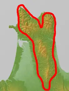
A map of the Tsugaru Peninsula with the Tsugaru Mountains outlined in red
The Tsugaru Mountains (津軽山地, Tsugaru-sanchi) are a mountain range on the Tsugaru Peninsula of Aomori Prefecture, in Honshū, Japan. The range stretches 60 km (37 mi) south-southeast from Cape Tappi on the northern end of the peninsula to the western flank of the volcanic Hakkōda Mountains south of the city of Aomori. The highest point in the range is Mount Maruyakata, measuring 718 meters (2,356 ft).[1]
It is made up of mountains ranging roughly between 200 and 700 meters (660 and 2,300 ft) in height. Some mountains in the range are Mount Bonju, Mount Maruyakata, Tongari-dake, and Mount Manogami.[2]
References
- ↑ "GSI Maps". Geospatial Information Authority of Japan. Retrieved 29 April 2020.
- ↑ Nemoto Naoki; Yoshihiro Ujiie. "青森県の地質" [Geology of Aomori Prefecture] (PDF) (in Japanese). Hirosaki University. Retrieved 29 April 2020.
This article is issued from Wikipedia. The text is licensed under Creative Commons - Attribution - Sharealike. Additional terms may apply for the media files.