| Trift Glacier | |
|---|---|
| Triftgletscher | |
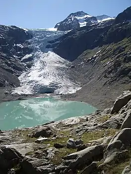
 Trift Glacier in September 2007 | |
 Trift Glacier Location in Switzerland | |
| Location | Canton of Berne, Switzerland |
| Coordinates | 46°39′40″N 8°22′40″E / 46.66111°N 8.37778°E |
| Length | 5 km |

The Trift Glacier (German: Triftgletscher) is a 5 km (3.1 mi) long glacier (2005) in the Urner Alps near Gadmen, in the extreme east of the canton Berne in Switzerland.[1]


Morphology
In 1973 glacier was 5.75 km long, 3 km wide at the top and around 500 m wide at it tongue. Overall it covered an area of 16.55 km2 (6.39 sq mi) including glacier sides. [2]
Since the end of the Little Ice Age, the Trift Glacier is shrinking. The valley in which lake Triftsee is today used to be filled by a large mass of ice well into the 20th century. In the 1990s smaller meltwater pools began to form at the glacier tongue and gradually increased in size. The hot summer of 2003 was particularly hard on the glacier. The lake quickly grew larger and the glacier tongue literally sank into the meltwater lake or dissolved into it.[3] This led to a shrinkage of the glacier of more than 136 m within just one year. From 1861 to 2021, the glacier shrunk a total of 3941 meters.
Tourist attractions
At an altitude of 2520 meters above sea level is the Trifthutte , a mountain hut of the Schweizer Alpen-Club (SAC) that was only accessible via the glacier tongue. Due to the melting of the glacier, in 2004 people were forced to build a bridge, the Triftbrücke to reach this hut.
See also
References
- ↑ Reynolds, Kev (2011). Walking in the Alps: A Comprehensive Guide to Walking and Trekking throughout the Alps. Kendal, UK: Cicerone Press. p. 197.
- ↑ (in German) Triftgletscher Gadmen, Schweizerisches Gletschermessnetz
- ↑ Lorenz King: Studien zur postglazialen Gletscher- und Vegetationsgeschichte des Sustenpassgebietes. –In: Basler Beiträge zur Geographie. volume 18. 125 pages, 3 pollen diagramms as annex, 1974.
External links