The Transcontinental Traverse (TCT) was a geodetic survey traverse conducted in the continental United States by the United States Coast and Geodetic Survey between 1961 and 1970 and the U.S. National Geodetic Survey between 1970 and 1976. It was the most accurate large-area survey ever done prior to Global Positioning System surveys. TCT included over 2,700 survey stations, covered over 13,600 miles (21,900 km), and passed through 44 U.S. states.[1]
This nationwide survey increased the accuracy of the existing U.S. survey network. It was also fundamental to the sophisticated mathematical readjustment of the nation's survey network known as the North American Datum of 1983.[2] It was the "end of an era" as the last conventional, purely terrestrial large scale survey.[3]
Forerunner surveys
The first major transcontinental survey was the Transcontinental Arc of Triangulation, completed in 1896 along the 39th parallel north with coastal endpoints at Cape May Lighthouse at Cape May, New Jersey, and Point Arena Light near Point Arena, California. It established the Meades Ranch survey marker, also called the Geodetic Center of the United States.[4][5]
The Transcontinental Traverse, commonly known as the "TCT", grew out of smaller surveying projects that the U.S. Coast and Geodetic Survey (USC&GS) conducted for the United States Air Force missile-tracking program in an area near Cape Canaveral, Florida, during the 1960s. The USC&GS developed unique specifications for this work that resulted in one part in 1,000,000, exceeding Air Force requirements.[6] This led USC&GS officials to conclude that applying the same specifications to a nationwide traverse, a surveying method, would dramatically improve the scale of the entire U.S. survey network. Soon after completing its work for the Air Force in Florida in 1961, the USC&GS embarked on the TCT.[2]
Route and history
The Geodimeter electronic distance measurement device was rapidly tested and adopted by U.S. national agencies for long-distance mapping. The last base line to be measured with tape happened near Salmon, Idaho, in 1958.[7]
The survey began in 1961 in Florida and ended in 1976 in Michigan. It crisscrossed North America along three east-west and five north-south corridors. A portion that had been planned to traverse the U.S.-Canada border to Maine was canceled due to advances in satellite geodesy.[7]
Equipment and methods

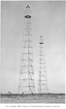
The traverse made use of the Geodimeter, a lightwave phase electronic distance measurement instrument that had just been invented when the traverse began.[8][9] The instruments were located atop Bilby towers many meters above ground level to avoid obscuring objects and to get a smoother air temperature profile for accuracy. Due to the light source then in use, the Geodimeter could only be operated at night.[10]
Satellite triangulation

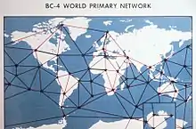
Photographic satellite triangulation stations were tied in to the traverse at Moses Lake, Washington; Chandler, Minnesota; Beltsville, Maryland; and four other locations. The Moses Lake and Beltsville sites became part of a worldwide satellite geodesy network.[11][12]
See also
References
- ↑ The High-precision Transcontinental Traverse: Improving the Scale of the U.S. Survey Network, NOAA (page "the traverse")
- 1 2 "The High-precision Transcontinental Traverse: Improving the Scale of the U.S. Survey Network", NOAA Celebrates 200 years (website), U.S. National Oceanographic and Atmospheric Administration
- ↑ Wilford2001, p. 366.
- ↑ Jerry Penry (June 4, 2015), "Meades Ranch", The American Surveyor, Cheves Media
- ↑ Milestones of the Survey, National Geodetic Survey, June 5, 2017
- ↑ Cape Canaveral Triangulation Survey Yields High-Precision Results, NOAA
- 1 2 Joseph F. Dracup, GEODETIC SURVEYING 1940 - 1990 – via NOAA
- ↑ "EDM (Geodimeter Model 2A)", Database: Physical Sciences Collection - Surveying and Geodesy, Smithsonian Institution, catalog number 1998.3094.01, retrieved 2018-05-02
- ↑ The High-precision Transcontinental Traverse: Improving the Scale of the U.S. Survey Network, NOAA (page "improving distance measurement")
- ↑ Paul Wise (2014), "NATMAP's INTRODUCTION OF ELECTRONIC DISTANCE MEASURING TO AUSTRALIA - SIXTY YEARS ON", Australian Web Archive, Government of Australia, archived from the original on 2018-02-26
{{citation}}: CS1 maint: bot: original URL status unknown (link) - ↑ National Academy of Sciences 1971, p. 80.
- ↑ Worldwide BC-4 Network, NOAA Photo Library
Sources
- Wilford, John Noble (2001), "Baselines across a continent", The Mapmakers, Vintage Books, pp. 353–366, ISBN 0375708502
- Committee on the North American Datum, National Academy of Sciences / National Research Council / National Academy of Engineering (1971), "Appendix D: High-precision transcontinental traverse surveys in the United States and Appendix E: Satellite Triangulation for North America", North American Datum: A Report, Issue 81, U.S. Government Printing Office, pp. 73–80, LCCN 72-608706
![]() This article incorporates public domain material from The High-precision Transcontinental Traverse: Improving the Scale of the U.S. Survey Network. United States Geological Survey. in NOAA Celebrates 200 years
This article incorporates public domain material from The High-precision Transcontinental Traverse: Improving the Scale of the U.S. Survey Network. United States Geological Survey. in NOAA Celebrates 200 years
Further reading
- Geodesy for the Layman, USAF via NOAA, 1959, mentions this traverse planned at the time
- C. Barton Crattie, Surveying and Towers for Triangulation With an Emphasis on the Bilby Steel Tower (PDF)
- James K. Richards (1965), Bilby Steel Tower for Triangulation (PDF), United States Coast and Geodetic Survey, Publication 62-3
External links
 Media related to Transcontinental Traverse at Wikimedia Commons