Tiszaföldvár | |
|---|---|
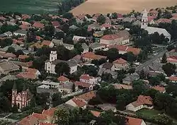
 Aerial view | |
 Flag  Coat of arms | |
 Tiszaföldvár Location of Tiszaföldvár | |
| Coordinates: 46°58′26″N 20°15′14″E / 46.97389°N 20.25389°E | |
| Country | |
| County | Jász-Nagykun-Szolnok |
| District | Kunszentmárton |
| Area | |
| • Total | 80.34 km2 (31.02 sq mi) |
| Population (2002) | |
| • Total | 12,027 |
| • Density | 150/km2 (390/sq mi) |
| Time zone | UTC+1 (CET) |
| • Summer (DST) | UTC+2 (CEST) |
| Postal code | 5430 |
| Area code | (+36) 56 |
| Website | tiszafoldvar |
Tiszaföldvár is a town in Jász-Nagykun-Szolnok county, in the Northern Great Plain region of central Hungary.
Geography
It covers an area of 80.34 km2 (31 sq mi) and has a population of 12,027 people (2002).
Politics
The current mayor of Tiszaföldvár is István Hegedűs (Independent).
The local Municipal Assembly, elected at the 2019 local government elections, is made up of 12 members (1 Mayor, 8 Individual constituencies MEPs and 3 Compensation List MEPs) divided into this political parties and alliances:[1]
| Party | Seats | Current Municipal Assembly | |||||
|---|---|---|---|---|---|---|---|
| Fidesz-KDNP | 5 | ||||||
| Patriots of Földvár | 3 | ||||||
| DK-MSZP | 2 | ||||||
| Independent | 2 | M | |||||
Twin towns – sister cities
Tiszaföldvár is twinned with:[2]
 Bačko Gradište (Bečej), Serbia (2006)
 Gräfenberg, Germany (2003)
 Hérimoncourt, France (2004)
 Mielec, Poland (2006)
Tiszaföldvár also cooperates with other Hungarian municipalities with "földvár" in their names: Balatonföldvár, Dunaföldvár and Pusztaföldvár.[3]
Gallery
 Tiszaföldvár name written in both Szekely-Hungarian script (bottom) and Latin letters (top)
References
- ↑ "Városi közgyűlés tagjai 2019-2024 - Tiszaföldvár (Jász-Nagykun-Szolnok megye)". valasztas.hu. Retrieved 2019-10-29.
- ↑ "Testvérvárosok (Menu)". tiszafoldvar.hu (in Hungarian). Tiszaföldvár. Retrieved 2021-04-10.
- ↑ "Földvárak". tiszafoldvar.hu (in Hungarian). Tiszaföldvár. Retrieved 2021-04-10.
External links
Wikimedia Commons has media related to Tiszaföldvár.
- Official website in Hungarian, English, German and French
This article is issued from Wikipedia. The text is licensed under Creative Commons - Attribution - Sharealike. Additional terms may apply for the media files.

