Location of Thurles in the civil parishes of North Tipperary

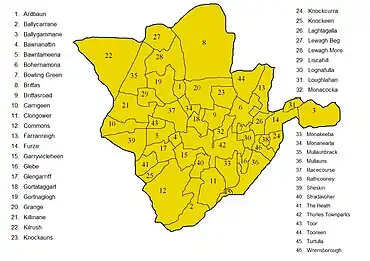
Map of the townlands in the parish
Thurles is a civil parish in the barony of Eliogarty in County Tipperary.
Church of Ireland parish
Like all civil parishes in Ireland, this civil parish is derived from, and co-extensive with, a pre-existing parish of the Church of Ireland.
Townlands
The parish is divided into 46 townlands,[1] one of which, Thurles Townparks, contains the historical core of the town of Thurles. These townlands are as follows:
- Ardbaun
- Ballycarrane
- Ballygammane
- Bawnanattin
- Bawntameena
- Bohernamona
- Bowling Green
- Brittas
- Brittasroad
- Carrigeen
- Clongower
- Commons
- Farranreigh
- Furze
- Garryvicleheen
- Glebe
- Glengarriff
- Gortataggart
- Gortnaglogh
- Grange
- Killinane
- Kilrush
- Knockauns
- Knockcurra
- Knockeen
- Laghtagalla
- Lewagh Beg
- Lewagh More
- Liscahill
- Lognafulla
- Loughlahan
- Monacocka
- Monakeeba
- Monanearla
- Mullaunbrack
- Mullauns
- Racecourse
- Rathcooney
- Sheskin
- Stradavoher
- The Heath
- Thurles Townparks
- Toor
- Tooreen
- Turtulla
- Wrensborough
References
- ↑ Thurles Civil Parish. However, the map on this web page is a little inaccurate, because it shows the wrong townland of Turtulla as belonging to the parish - there are actually two neighbouring townlands of this name, one in Thurles civil parish and one which belongs to Fertiana civil parish.
This article is issued from Wikipedia. The text is licensed under Creative Commons - Attribution - Sharealike. Additional terms may apply for the media files.