Thakurnagar
ঠাকুরনগর | |
|---|---|
Town | |
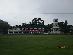
 Thakurnagar Matua Mahasangha Thakurbari | |
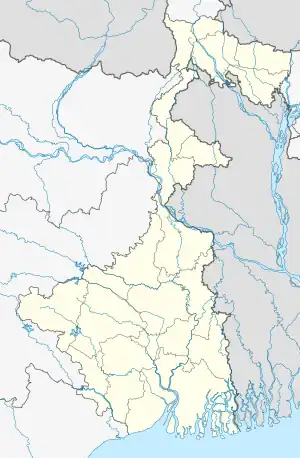
 Thakurnagar Location in West Bengal, India  Thakurnagar Thakurnagar (India) | |
| Coordinates: 22°55′28″N 88°46′40″E / 22.92444°N 88.77778°E | |
| Country | |
| State | West Bengal |
| District | North 24 Parganas |
| Founded by | Guruchand Thakur |
| Named for | Pramath Ranjan Thakur |
| Seat | Panchayet |
| Government | |
| • Type | Panchayet Raj |
| • MP | Shantanu Thakur (Bharatiya Janata Party) |
| • MLA | Subrata Thakur (Bharatiya Janata Party) |
| Languages | |
| Time zone | UTC+5:30 (IST) |
| PIN | 743287 |
| Telephone | 03215 |
| ISO 3166 code | IN-WB |
| Vehicle registration | WB-23, WB-24, WB-25, WB-26, WB-27, WB-28. |
| Official Languages | Bengali, English |
| Division | Presidency Division |
| Vidhanshabha Constituency | Gaighata |
| Lokshaba Constituency | Bangaon |
| Website | http://www.north24parganas.nic.in |
Thakurnagar is a town in the Indian state of West Bengal. It is close to the border with Bangladesh. It is situated on the east side of the Jessore Road. Thakurnagar is famous for "Baruni Mela".
History
Thakurnagar is named after Pramath Ranjan Thakur, the great-grandson of the founder of the Hindu Matuan movement, Harichand Thakur.[1] Due to the Thakurs' significance to the Matua Mahasangha, the village is considered the "Mecca of Matuas."[2]
Today, Thakurnagar is best known for the nearby Thakur Bari ("House of the Thakurs" in English). Thakurnagar is also known for its large flower market. It hosts a famous Baruni Mela.[3]
Geography
M: municipal town, CT: census town, R: rural/ urban centre, T: place of tourist interest
Owing to space constraints in the small map, the actual locations in a larger map may vary slightly
Location
Thakurnagar is located 63.4 km northeast of Kolkata. It is to the east of the Bangladesh border.
There have been reports of the formation of a Thakurnagar municipality in near future.[4] However, as of May 2018, no notification has been issued to that effect.[5][6]
Area overview
The area shown in the map was a part of Jessore district from 1883.[7][8] At the time of Partition of Bengal (1947) the Radcliffe Line placed the police station areas of Bangaon and Gaighata of Jessore district in India and the area was made a part of 24 Parganas district.[9][10] It is a flat plain located in the lower Ganges Delta.[11] In the densely populated area, 16.33% of the population lives in the urban areas and 83.67% lives in the rural areas.[12][13]
Note: The map alongside presents some of the notable locations in the subdivision. All places marked in the map are linked in the larger full screen map.
Health concern
The ground water in North 24 Parganas district is affected by arsenic contamination.[14]
Demographics
In the 2011 Census of India, Thakurnagar was not identified as a separate city. The population is included in that of nearby cities, but it is not differentiated in the census records.[15][16] In 2014, Chief Minister Mamata Banerjee announced, on behalf of the West Bengal government, the establishment of Thakurnagar Municipality.
See also
References
- ↑ "Eye on Bengal, visit to Matua mandir". The Times of India. 14 March 2021.
- ↑ Bagchi, Suvojit (26 April 2016). "In West Bengal, the die is cast here". The Hindu. ISSN 0971-751X. Retrieved 8 July 2018.
- ↑ "শুরু হচ্ছে ঠাকুরনগরের মতুয়া ধর্মালম্বীদের বারুনী মেলা". 29 March 2022.
- ↑ "Decentralisation of governance: 22 new municipalities to come up in Bengal : All India Trinamool Congress". aitcofficial.org. Retrieved 4 July 2018.
- ↑ "দুই জেলায় নতুন তিন পুরসভার ঘোষণায় উচ্ছ্বাস (Announcement of three new municipalities in two districts greeted)" (in Bengali). Ananda Bazar Patrika, 14 June 2014. Retrieved 28 May 2018.
- ↑ "West Bengal to have 22 new municipalities". Outlook 11 June 2014. Retrieved 28 May 2018.
- ↑ "Bengal District Gazetteers, Jessore by L.S.S. O'Malley". Chapter II: History, Page/ Section 44. Bengal Secretariat Book Depot, 1912. Retrieved 11 May 2018.
- ↑ "District Gazetteer" (PDF). Chapter IX: General Administration, Page 150. Egiye Bangla. Retrieved 11 May 2018.
- ↑ "Jessore District Information". Khujbo.com. Retrieved 11 May 2018.
- ↑ "Bibhutibhusan Bandopadhyay". Banglapedia. Retrieved 22 June 2021.
- ↑ "District Census Handbook North Twenty Four Parganas, Census of India 2011, Series 20, Part XII A" (PDF). Page 13. Directorate of Census Operations, West Bengal. Retrieved 16 April 2018.
- ↑ "District Statistical Handbook". North 24 Parganas 2013, Tables 2.1, 2.2, 2.4b. Department of Statistics and Programme Implementation, Government of West Bengal. Archived from the original on 21 January 2019. Retrieved 2 May 2018.
- ↑ "District Census Handbook North Twenty Four Parganas, Census of India 2011, Series 20, Part XII A" (PDF). Map of North Twenty Four Parganas with CD Block HQs and Police Stations (on the fifth page). Directorate of Census Operations, West Bengal. Retrieved 2 May 2018.
- ↑ "Arsenic in Ground Water of North 24 Parganas District, West Bengal | इंडिया वाटर पोर्टल (हिन्दी)". hindi.indiawaterportal.org (in Hindi). Retrieved 4 July 2018.
- ↑ "C.D. Block Wise Primary Census Abstract Data(PCA)". West Bengal – District-wise CD Blocks. Registrar General and Census Commissioner, India. Retrieved 27 May 2018.
- ↑ "District Census Handbook North Twenty Four Parganas, Census of India 2011, Series 20, Part XII A" (PDF). Page 227: Map of Gaighata CD Bloc. Directorate of Census Operations, West Bengal. Retrieved 27 May 2018.
