Tha Khanun
ท่าขนุน | |
|---|---|
Town | |
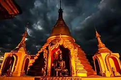
 Wat Tha Khanun | |
 Tha Khanun Location in Thailand | |
| Coordinates: 14°44′18″N 98°37′55″E / 14.7382°N 98.6320°E | |
| Country | Thailand |
| Province | Kanchanaburi Province |
| Population (2014)[1] | |
| • Total | 14,141 |
| Time zone | UTC+7 (ICT) |
Tha Khanun (Thai: ท่าขนุน) is a town and subdistrict (tambon) of Thong Pha Phum district of the Kanchanaburi Province, Thailand. It is named after the Jackfruit tree, and is located on the Khwae Noi River.[2] Lam Khlong Ngu National Park and Wat Tha Khanun, a large Buddhist temple, are located near the town.
History
Tha Khanun was a river harbour town on the Khwae Noi River. In 1786, Rama I landed his troops in Tha Khanun from Bangkok to fight the Burmese–Siamese War.[2] During the 20th century, an important part of the economy was wolfram mining in the nearby mountains.[3] Before the construction of roads, ore was transported by elephants from the mines to the harbour of Tha Khanun, and shipped by boat to Kanchanaburi.[4]
During World War II, it was the location of three prisoner of war camps along the Burma Railway, and was described as a large town with shops, a police station, and many fruit trees.[3][5] Lam Khlong Ngu National Park is located in the subdistrict and is known for its caves.[6] In 1986, the Vajiralongkorn Dam was constructed on the Khwae Noi River near the town.[7]
Wat Tha Khanun is a large Buddhist temple with a golden stupa. It is located on top of a mountain overlooking the town and the river. The temple can be reached via a 285 step staircase from the south side of the mountain.[8]
Camp Takanun
Camp Takanun were three Japanese prisoner of war camps constructed during World War II. The first prisoners arrived in October 1942.[5] The camps were reasonable at first, however there was a cholera outbreak in Camp 206[3] which caused 180 deaths in one month.[5] While cholera ravaged the prisoners of war, thousands of conscripted Asian workers were brought into Takanun.[3] The camps were abandoned in March 1944.[5]
References
- ↑ "รายงานสถิติจำนวนประชากรและบ้านประจำปี พ.ศ.2557". Department of Provincial Administration (in Thai). Retrieved 29 January 2022.
- 1 2 "ประวัติวัดท่าขนุน". Wat Tha Khanun (in Thai). Retrieved 29 January 2022.
- 1 2 3 4 "Tha Khanun South". Far East POW Family. Retrieved 29 January 2022.
- ↑ Brown, Glen F.; Sresthaputra, Vija; Johnston, Wiliam D. Jr. (1951). "The Pilok tungsten-tin district, Kanchanaburi". Geologic reconnaissance of the mineral deposits of Thailand (Report). Geological Survey Bulletin 984. U. S. Govt. Print. Off. pp. 105–106.
- 1 2 3 4 "Takanun". Japanse Krijgsgevangenkampen (in Dutch). Retrieved 29 January 2022.
- ↑ "Lam Khlong Ngu National Park Renger Section L.Ng.1". Ceediz. Retrieved 29 January 2022.
- ↑ "Vajiralongkorn Dam". Electricity Generating Authority of Thailand. Retrieved 29 January 2022.
- ↑ "Wat Tha Khanun". Lonely Planet. Retrieved 29 January 2022.