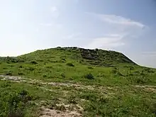
תל זית | |
 Tel Zayit | |
 Shown within Israel | |
| Location | |
|---|---|
| Region | Shfela |
| Coordinates | 31°37′45″N 34°49′49″E / 31.62917°N 34.83028°E |
| Type | Tell |
| History | |
| Periods | Late Bronze Age, Iron Age |
| Cultures | Canaanite, Israelite |
Tel Zayit (Hebrew: תל זית, Arabic: Tell Zeita, Kirbat Zeita al Kharab[1]) is an archaeological tell in the Shephelah, or lowlands, of Israel, about 30 km east of Ashkelon.
History
The site, roughly 0.8-acre (0.32 ha), shows evidence of human settlement throughout the Late Bronze Age, and Iron Age I and II. The city was destroyed by fire twice, in 1200 BCE and the ninth century BCE. Hazael of Aram may have been the military leader who ordered the destruction of the city in the ninth century BCE. The Arameans' siege tactics are known from the Zakkur stele, which records that Hazael's son, called Ben-Hadad, employed spectacular siege warfare against his enemies. The Hebrew Bible records that Hazael devastated cities in the Shephelah during the ninth century BCE, including the Philistine city of Gath.[2] The similar siege and destruction in 9th century BCE of Tell es-Safi, a nearby site usually identified as Gath, has been cited by archaeologists as possible evidence of Hazael's campaign.[3]
From at least the 16th century until some time during the 20th century, the site was occupied by the Arab village Zayta.[4] During the period of the British mandate, the village moved 1.5 km to the north. It was depopulated in 1948.[4]
Work at Tel Zayit began with a preliminary survey in 1998 by a Pittsburgh Theological Seminary team led by Ron Tappy.[5]
During the 2005 season, archaeologists discovered the Zayit Stone among the ruins of a fire dating to the tenth century BC. Alternatively, a 9th-century BC date has been suggested.[6] The stone includes an inscription identified by some scholars as an abecedary, among the oldest ever discovered.[7]
See also
References
- ↑ Survey of Palestine, Map 12: Hebron, 1:100,000, 1941–1946
- ↑ 2 Kings 8:12
- ↑ Maeir, A., and Ehrlich, C. "Excavating Philistine Gath - Have We Found Goliath's Hometown?" in Biblical Archaeology Review 27(6): 22–31. 2001; Maeir, A. 2004. "The Historical Background and Dating of Amos VI 2: An Archaeological Perspective from Tell es-Safi/Gath," Vetus Testamentum 54(3):319–334.
- 1 2 Walid Khalidi (1992). All That Remains: The Palestinian Villages Occupied and Depopulated by Israel in 1948. Washington D.C.: Institute for Palestine Studies. p. 227.
- ↑ Ron E. Tappy, "The 1998 Preliminary Survey of Khirbet Zeitah el-Kharab (Tel Zayit) in the Shephelah of Judah," Bulletin of the American Schools of Oriental Research, no. 319, pp. 7–36, 2000
- ↑ Israel Finkelstein, Benjamin Sass and Lily Singer-Avitz, "Writing in Iron IIA Philistia in the Light of the Tẹ̄l Zayit/Zētā Abecedary," Zeitschrift des Deutschen Palästina-Vereins, Bd. 124, H. 1, pp. 1–14, 2008
- ↑ Tappy, Ron E., P. Kyle McCarter, Marilyn J. Lundberg, Bruce Zuckerman (2006). "An Abecedary of the Mid-Tenth Century B.C.E. from the Judaean Shephelah". BASOR. 344 (November): 5–46.
{{cite journal}}: External link in|journal=
Further reading
- Ron E. Tappy and P. Kyle McCarter, Literate Culture and Tenth-century Canaan: The Tel Zayit Abecedary in Context, Eisenbrauns, 2008, ISBN 1-57506-150-3
External links
- Yoav Vaknin, Ron Shaar, Oded Lipschits, and Erez Ben-Yosef (2022). "Reconstructing biblical military campaigns using geomagnetic field data". Proceedings of the National Academy of Sciences. 119 (44). e2209117119. Bibcode:2022PNAS..11909117V. doi:10.1073/pnas.2209117119. PMC 9636932. PMID 36279453.
{{cite journal}}: CS1 maint: multiple names: authors list (link) - Tel Zayit excavations
- PBS video on Tel Zayit