Szopienice-Burowiec | |
|---|---|
 Szopienice | |
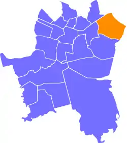
 Location of Szopienice-Burowiec within Katowice | |
| Coordinates: 50°16′07.475″N 19°05′03.106″E / 50.26874306°N 19.08419611°E | |
| Country | |
| Voivodeship | Silesian |
| County/City | Katowice |
| Area | |
| • Total | 8.47 km2 (3.27 sq mi) |
| Population (2007) | |
| • Total | 17,139 |
| • Density | 2,000/km2 (5,200/sq mi) |
| Time zone | UTC+1 (CET) |
| • Summer (DST) | UTC+2 (CEST) |
| Area code | (+48) 032 |
| Vehicle registration | SK |
| Primary airport | Katowice Airport |
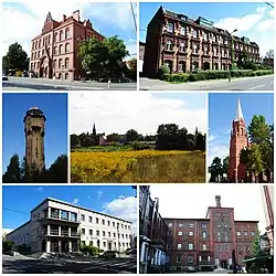
Szopienice-Burowiec (German: Schoppinitz-Burowietz) is a district of Katowice, Poland, located in the north-eastern part of the city. It has an area of 8.47 km2 and in 2007 had 17,139 inhabitants.[1]
The area of a district encompasses two historically important settlements: Roździeń and Szopienice.
Shortly after the German invasion of Poland, which started World War II in September 1939, a unit of the German Einsatzgruppe I was stationed in Szopienice.[2] It was responsible for many crimes against Poles committed in the nearby cities of Będzin, Dąbrowa Górnicza and Sosnowiec.[2] During the subsequent German occupation, the occupiers also established and operated the E734 forced labour subcamp of the Stalag VIII-B/344 prisoner-of-war camp in Szopienice.[3] The occupation ended in 1945.
Notable people
- Hilary Krzysztofiak (1926–1979), Polish painter, graphic artist and set designer
- Piotr Libera (b. 1951), Roman Catholic bishop
Gallery
 Plac Powstańców Śląskich ("Silesian Insurgents' Square")
 Church of St. Hedwig, High Duchess consort of Poland
.jpg.webp) Silesian Uprisings Monument
Silesian Uprisings Monument Park Olimpijczyków ("Olympians' Park")
 Ulica Wiosny Ludów ("Spring of Nations Street") with the Primary School No. 42 on the left
 Primary School No. 44
 Former brewery complex
 Pesa Twist 2012N tram at Ulica Obrońców Westerplatte ("Defenders of Westerplatte Street") in Roździeń
References
- ↑ Urząd Miasta Katowice. "Katowice - Studium uwarunkowań i kierunków zagospodarowania przestrzennego" (PDF) (in Polish). Archived from the original (PDF) on 2011-11-04. Retrieved 2011-06-16.
- 1 2 Warzecha, Bartłomiej (2003). "Niemieckie zbrodnie na powstańcach śląskich w 1939 roku". Biuletyn Instytutu Pamięci Narodowej (in Polish). No. 12–1 (35–36). IPN. p. 56. ISSN 1641-9561.
- ↑ "Working Parties". Lamsdorf.com. Archived from the original on 29 October 2020. Retrieved 3 April 2021.