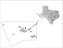
Stockton Bend, Texas | |
|---|---|
 Location of Stockton Bend, Texas | |
| Coordinates: 32°28′41″N 97°45′37″W / 32.47806°N 97.76028°W | |
| Country | United States |
| State | Texas |
| County | Hood |
| Area | |
| • Total | 0.94 sq mi (2.43 km2) |
| • Land | 0.629 sq mi (1.628 km2) |
| • Water | 0.31 sq mi (0.80 km2) |
| Elevation | 702 ft (214 m) |
| Population | |
| • Total | 380 |
| • Density | 604.13/sq mi (233.36/km2) |
| Time zone | UTC-6 (Central (CST)) |
| • Summer (DST) | UTC-5 (CDT) |
| ZIP code | 76048 |
| Area code | 817 |
| FIPS code | 48-10087 |
| GNIS feature ID | 2083667[2] |
Stockton Bend, formerly Brazos Bend, is a city in Hood County, Texas, United States. It was incorporated in May 2004[4] originally as "Brazos Bend", and is located along the main stem of the Brazos River. As of the 2020 census it had a population of 380.[3] The city is part of the Granbury, Texas Micropolitan Statistical Area. The name was recently changed to "Stockton Bend".
Geography
| Census | Pop. | Note | %± |
|---|---|---|---|
| 2010 | 305 | — | |
| 2020 | 380 | 24.6% | |
| U.S. Decennial Census[3] | |||
The city is in northeast-central Hood County, on both sides of the Brazos River where it is impounded as Lake Granbury. There is no bridge within the city limits connecting the two parts of the city. The majority of the city is on the west side of the river, occupying the inside of the Stockton Bend river attribute. The city is 4 miles (6 km) northeast of Granbury, the Hood county seat.
Education
The Granbury Independent School District serves area students.
External links
Information on the city government is available at the Texas Municipal League
References
- ↑ "2021 U.S. Gazetteer Files". United States Census Bureau. Retrieved May 22, 2022.
- 1 2 U.S. Geological Survey Geographic Names Information System: Stockton Bend, Texas
- 1 2 3 "Stockton Bend city, Texas Demographics and Housing 2020 Decennial Census".
- ↑ "Boundary Changes". Geographic Change Notes: Texas. Population Division, United States Census Bureau. May 19, 2006. Archived from the original on August 6, 2010. Retrieved May 27, 2008.
