| Simon B. Elliott State Park | |
|---|---|
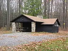
 CCC-built stone pumphouse and picnic pavilion at S. B. Elliott State Park | |
 Location of S. B. Elliott State Park in Pennsylvania  Simon B. Elliott State Park (the United States) | |
| Location | Pine, Clearfield, Pennsylvania, United States |
| Coordinates | 41°06′30″N 78°31′58″W / 41.10833°N 78.53278°W |
| Area | 318 acres (129 ha)[1] |
| Elevation | 2,119 ft (646 m)[2] |
| Established | 1933 |
| Named for | Simon B. Elliott |
| Governing body | Pennsylvania Department of Conservation and Natural Resources |
| Website | S. B. Elliott State Park |
Simon B. Elliott State Park is a 318-acre (129 ha) Pennsylvania state park located in Pine Township, Clearfield County, Pennsylvania in the United States. The park is surrounded by Moshannon State Forest. The park is entirely wooded with second growth forests of mixed oak species, including northern red oak, chestnut oak, shagbark hickory, red maple, and tulip poplar, and northern hard woods, including sugar maple, black cherry, aspen, birch, hemlock, and ash.[3] S. B. Elliott State park is 9 miles (14 km) north of Clearfield on Pennsylvania Route 153 just off exit 111 of Interstate 80.
History
By the mid-19th century, the demand for lumber reached Clearfield County, where white pine and hemlock covered the mountainsides. Lumbermen came and harvested the trees. The Central Pennsylvania Lumber Company and Goodyear Lumber Company owned thousands of acres in Clearfield and surrounding counties. They built railroads and roads to harvest and distribute the timber. The lumber boom era was not to last, and soon all the trees were gone. Once the trees disappeared, the people were soon to follow. The lumbermen left behind a barren landscape that was devastated by erosion and wildfires. The Commonwealth of Pennsylvania bought the thousands of acres of deforested and burned land. The state began the massive project of reforesting the land. The forest has since recovered and is part of Moshannon State Forest.[1]
The park is named for the Honorable Simon B. Elliott. He was a member of the Pennsylvania General Assembly, and a conservationist who promoted the idea of replanting the forests in order to limit erosion and fires.[1]
The park was built in 1933 by the Civilian Conservation Corps. The young men of Camp S-116-PA built many of the cabins, roads, pavilions, and trails that exist at the park today. They also cleared brush, cleaned streams, built roads and bridges, and planted trees as part of a reforestation effort. The CCC also placed a plaque honoring Simon B. Elliott in the woods on the northern edge of the park.[4]

Recreation
Fishing at S. B. Elliott State Park is a popular recreational activity. There is a population of native and stocked trout in the small mountain streams of the park. They can only be accessed by hiking through the woods on one of the three miles (5 km) of hiking trails.[1]
The CCC built several cabins and pavilions that are available for camping and picnicking. There is a 25 site rustic campground at S. B. Elliott State Park. There is a modern restroom near the camping area, but there are no showers.[1]
Hunting is permitted on about 234 acres (95 ha) of S. B. Elliott State Park. Hunters are expected to follow the rules and regulations of the Pennsylvania State Game Commission. The common game species are ruffed grouse, eastern gray squirrel, wild turkey, white-tailed deer, and common pheasant. Many more acres of forested woodlands are available for hunting on the grounds of the adjacent Moshannon State Forest.[1]
Nearby state parks
The following state parks are within 30 miles (48 km) of S. B. Elliott State Park:[5][6][7]
|
References
- 1 2 3 4 5 6 "Simon B. Elliott State Park". Pennsylvania Department of Conservation and Natural Resources. Archived from the original on October 2, 2011. Retrieved November 18, 2006.
- ↑ "S. B. Elliott State Park". Geographic Names Information System. United States Geological Survey. August 2, 1979. Retrieved December 18, 2007.
- ↑ "Forests and Trees". Pennsylvania Dept. of Conservation and Natural Resources. July 25, 2022.
- ↑ "Pennsylvania State Parks: The CCC Years". Pennsylvania Department of Conservation and Natural Resources. Archived from the original on February 5, 2004. Retrieved November 28, 2006.
- ↑ "Find a Park by Region (interactive map)". Pennsylvania Department of Conservation and Natural Resources. Archived from the original on September 24, 2011. Retrieved November 18, 2011.
- ↑ 2007 General Highway Map Clearfield County Pennsylvania (PDF) (Map). 1:65,000. Pennsylvania Department of Transportation, Bureau of Planning and Research, Geographic Information Division. Retrieved July 27, 2007. Note: shows S. B. Elliott State Park
- ↑ Michels, Chris (1997). "Latitude/Longitude Distance Calculation". Northern Arizona University. Retrieved April 23, 2008.
External links
- "S. B. Elliott State Park official map" (PDF). Archived from the original (PDF) on November 14, 2012. (361.1 KB)
