Sherpur Sadar
শেরপুর সদর | |
|---|---|
| Sherpur Sadar | |
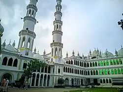
 Mai Saheba Jame Masjid | |
.svg.png.webp) | |
| Coordinates: 25°0′N 90°1′E / 25.000°N 90.017°E | |
| Country | |
| Division | Mymensingh Division |
| District | Sherpur District |
| Government | |
| • Mayor | Golam Kibriya Liton |
| • UNO | Firoz Al Mamun |
| Area | |
| • Total | 372.89 km2 (143.97 sq mi) |
| Population (2011) | |
| • Total | 497,179 |
| • Density | 1,300/km2 (3,500/sq mi) |
| Time zone | UTC+6 (BST) |
| Postal code | 2100 |
| Website | Official Website |
Sherpur Sadar (Bengali: শেরপুর সদর) is an upazila of Sherpur District in the Division of Mymensingh, Bangladesh.[1][2][3][4]
Demographics
According to the 2011 Bangladesh census, Sherpur Sadar Upazila had 122,280 households and a population of 497,179. 126,565 (24.41%) were under 10 years of age. Sherpur Sadar has a literacy rate (age 7 and over) of 36.7%, compared to the national average of 51.8%, and a sex ratio of 986 females per 1000 males. 97,979 (19.71%) lived in urban areas.[5][6]
According to the 2001 Bangladesh census, Sherpur upazila had a population of 449,798; males constituted 234,296, females 215,502; Muslim 437,227, Hindu 11,439, Buddhist 517, Christian 15 and others 600.[4]
As of the 1991 Bangladesh census, Sherpur Sadar had a population of 381,419. Males constituted 51.58% of the population, and females 48.42%. This Upazila's eighteen up population was 189,019. Sherpur Sadar had an average literacy rate of 78.23% (7+ years), and the national average of 32.4% literate.[7]
Administration
Sherpur Sadar Thana was turned into an upazila in 1984.[4]
Sherpur Sadar Upazila is divided into Sherpur Municipality and 14 union parishads: Bajitkhila, Balairchar, Betmari Ghughurakandi, Chormochoriya, Chorpokhimari, Chorsherpur, Dhola, Gajirkhamar, Kamarar Chor, Kamariya, Losmonpur, Pakuriya, Rouha, and Vatshala. The union parishads are subdivided into 100 mauzas and 188 villages.[8]
Sherpur Municipality is subdivided into 9 wards and 46 mahallas.[8]
Education

There are 11 colleges in the upazila: Sherpur Government College.,[9] Sherpur Government Mohila College, Beer Muktijodda Atiur Rahman Model College, Dr. Sekander Ali College, Jamsad Ali Memorial College, Kamarar Char College, Model Girls College, Sherpur, Nizam Uddin Ahmed Model College, Sanuwer Hosen Model College, Shahid Abdur Rashid Commerce College and Sherpur Biggan College. Other schools include Ideal Preparatory and High School (1991), Govt victoria academy, Govt girls high school, and Nobarun public school.
According to Banglapedia, Sherpur Government Victoria Academy (1887), GK Pilot High School, founded in 1919, Sapmari High School (1907), and Sherpur High School (1920) are notable secondary schools.[4] Sherpur is the birthplace of numerous highly educated doctors and engineers, also people of different occupations.
See also
References
- ↑ Sherpur District Statistics 2011
- ↑ বাংলাদেশ জাতীয় তথ্য বাতায়ন
- ↑ Bangladesher Lokojo Sonskriti Gronthamala : Sherpur, Bangla Academy
- 1 2 3 4 Sakil Ahmed Shahriar Milton (2012), "Sherpur Sadar Upazila", in Sirajul Islam and Ahmed A. Jamal (ed.), Banglapedia: National Encyclopedia of Bangladesh (Second ed.), Asiatic Society of Bangladesh
- 1 2 "Community Tables: Sherpur district" (PDF). bbs.gov.bd. 2011.
- ↑ "Bangladesh Population and Housing Census 2011 Zila Report – Sherpur" (PDF). bbs.gov.bd. Bangladesh Bureau of Statistics.
- ↑ "Population Census Wing, BBS". Archived from the original on 2021-08-27. Retrieved November 10, 2006.
- 1 2 "District Statistics 2011: Sherpur" (PDF). Bangladesh Bureau of Statistics. Archived from the original (PDF) on 13 November 2014. Retrieved 14 July 2014.
- ↑ "List of Colleges". Department of Secondary and Higher Education. Retrieved 6 September 2020.
