Rtyně v Podkrkonoší | |
|---|---|
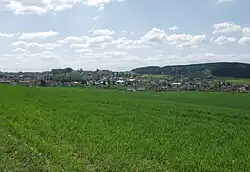
 Panorama of Rtyně v Podkrkonoší | |
 Flag  Coat of arms | |
 Rtyně v Podkrkonoší Location in the Czech Republic | |
| Coordinates: 50°30′19″N 16°4′19″E / 50.50528°N 16.07194°E | |
| Country | |
| Region | Hradec Králové |
| District | Trutnov |
| First mentioned | 1367 |
| Government | |
| • Mayor | Stanislav Řezníček |
| Area | |
| • Total | 13.89 km2 (5.36 sq mi) |
| Elevation | 405 m (1,329 ft) |
| Population (2023-01-01)[1] | |
| • Total | 2,932 |
| • Density | 210/km2 (550/sq mi) |
| Time zone | UTC+1 (CET) |
| • Summer (DST) | UTC+2 (CEST) |
| Postal code | 542 33 |
| Website | www |
Rtyně v Podkrkonoší (German: Hertin) is a town in Trutnov District in the Hradec Králové Region of the Czech Republic. It has about 2,900 inhabitants.
Geography
Rtyně v Podkrkonoší is located about 13 km (8 mi) southeast of Trutnov and 36 km (22 mi) northeast of Hradec Králové. It lies on the border between the Giant Mountains Foothills and Broumov Highlands. The highest point is a hill at 642 m (2,106 ft) above sea level. The Rtyňka stream flows through the town.
History
Rtyně was probably founded in the late 13th century.[2] The first written mention of Rtyně is from 1367 when it used to be one of the biggest agricultural communities in the region. The way of living changed a lot in the 16th century when coal mining in this region started, although the agriculture did not lose its importance.[3]
Peasants used to keep an important position in Rtyně, which was proved by a peasant uprising in 1775. Coal mining as well as the uprising is remembered in the exposition of the town museum.[3]
In 1931, the name of the municipality was changed to Rtyně v Podkrkonoší. In 1978, it gained town status.[3]
Demographics
|
|
| ||||||||||||||||||||||||||||||||||||||||||||||||||||||
| Source: Censuses[4][5] | ||||||||||||||||||||||||||||||||||||||||||||||||||||||||
Economy
The largest employer based in the town is Joyson Safety Systems, a manufacturer of automotive safety systems.
Culture
Since 1962, the town hosts an annual concert band festival. The town is also the seat of the Koletova hornická hudba Concert Band, which was founded in 1864 and is the host band for the annual band festival.[6]
Sights
_-_kostel_sv._Jana_K%C5%99titele_a_zvonice.JPG.webp)
The most valuable building and symbol of the town is a wooden bell tower from 1592. It is unique in shape and construction. It is located next to the Church of Saint John the Baptist. In front of the church there is a statue of King David by Matthias Braun. Due to poor condition, the original from 1738 was replaced by a copy.[7][8]
Twin towns – sister cities
Rtyně v Podkrkonoší is twinned with:[9]
 Elstra, Germany
 Jelcz-Laskowice, Poland
References
- ↑ "Population of Municipalities – 1 January 2023". Czech Statistical Office. 2023-05-23.
- ↑ "Historický vývoj" (in Czech). Město Rtyně v Podkrkonoší. Retrieved 2021-09-25.
- 1 2 3 "Základní informace" (in Czech). Město Rtyně v Podkrkonoší. Retrieved 2021-09-25.
- ↑ "Historický lexikon obcí České republiky 1869–2011 – Okres Trutnov" (in Czech). Czech Statistical Office. 2015-12-21. pp. 11–12.
- ↑ "Population Census 2021: Population by sex". Public Database. Czech Statistical Office. 2021-03-27.
- ↑ "Historie" (in Czech). Koletova hornická hudba. Retrieved 2021-09-25.
- ↑ "Památky" (in Czech). Město Rtyně v Podkrkonoší. Retrieved 2021-09-25.
- ↑ "Rtyně v Podkrkonoší" (in Czech). Kudy z nudy. Retrieved 2021-09-25.
- ↑ "Užitečné odkazy" (in Czech). Město Rtyně v Podkrkonoší. Retrieved 2021-09-25.