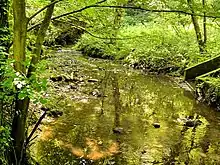
River Chor near Chorley
The River Chor is a largely culverted stream in the Lancashire town of Chorley. Its name was back-formed from "Chorley".
The source of the river is in the hills near Heapey.
Subsequently, the young stream flows through Chorley North Industrial Estate, past B&Q and then underground to enter Astley Park from under Park Road.
The river exits at the Southport Road end of the park, flowing behind Chorley Nissan and through Big Wood at the foot of Stansted Road, before connecting into Gillibrand Reservoir.
At the end of the reservoir, the river continues for approximately one hundred metres and flows into the River Yarrow.[1]
References
- ↑ Capper, Benjamin Pitts (1808). A Topographical Dictionary Of the United Kingdom. London: Richard Phillips. p. CHO in original book, p. 259 in Google Books PDF. Retrieved 15 December 2019 – via Internet Archive.
Chorley is situated near the spring-head of the river Chor, which issuing from several springs, and running through the town, falls into the Yarrow, after giving motion to numerous mills on its banks.
53°38′49″N 2°39′21″W / 53.6469°N 2.6559°W
This article is issued from Wikipedia. The text is licensed under Creative Commons - Attribution - Sharealike. Additional terms may apply for the media files.
