| Rewan Queensland | |||||||||||||||
|---|---|---|---|---|---|---|---|---|---|---|---|---|---|---|---|
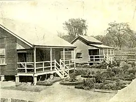
 Rewan station buildings and garden, 1910 | |||||||||||||||
 Rewan | |||||||||||||||
| Coordinates | 24°58′03″S 148°23′08″E / 24.9675°S 148.3855°E | ||||||||||||||
| Population | 49 (SAL 2021)[1] | ||||||||||||||
| Postcode(s) | 4702 | ||||||||||||||
| Area | 2,068.5 km2 (798.7 sq mi) | ||||||||||||||
| Time zone | AEST (UTC+10:00) | ||||||||||||||
| Location |
| ||||||||||||||
| LGA(s) | Central Highlands Region | ||||||||||||||
| State electorate(s) | Gregory | ||||||||||||||
| Federal division(s) | Flynn | ||||||||||||||
| |||||||||||||||
Rewan is a rural locality in the Central Highlands Region, Queensland, Australia.[2] In the 2021 census, Rewan had a population of 49 people.[3]
Geography
The Carnarvon Highway enters the locality from the north (Consuelo), then runs south through the locality, exiting to the south (Carnarvon Park).[4][5]
The terrain is mountainous with many named peaks (from north to south):
- Mount Inglis (24°45′00″S 148°16′40″E / 24.7501°S 148.2778°E) 766 metres (2,513 ft)[6][7]
- Mount Hades (24°46′50″S 148°06′07″E / 24.7805°S 148.1020°E) 1,000 metres (3,300 ft)[6][8]
- Mount Flank (24°48′05″S 148°20′06″E / 24.8014°S 148.3349°E) 647 metres (2,123 ft)[6][9]
- Mount Serocold (24°50′12″S 148°16′44″E / 24.8366°S 148.2790°E) 900 metres (3,000 ft)[6][10]
- Mount Hornet (24°51′58″S 148°16′37″E / 24.8660°S 148.2769°E) 925 metres (3,035 ft)[6][11]
- Mount Carnarvon (24°54′49″S 148°22′45″E / 24.9136°S 148.3791°E) 631 metres (2,070 ft)[6][12]
- Mount Kirk (24°57′37″S 148°41′44″E / 24.9602°S 148.6955°E) 472 metres (1,549 ft)[6][13]
- Mount Warrinilla (24°59′01″S 148°40′23″E / 24.9837°S 148.6730°E) 440 metres (1,440 ft)[6][14]
- The Crater (25°03′17″S 148°24′35″E / 25.0548°S 148.4098°E)[6][15]
- Mount Round (25°03′57″S 148°24′54″E / 25.0658°S 148.4151°E) 462 metres (1,516 ft)[6][16]
Nuga Nuga National Park is in the east of the locality. One part of Serocold State Forest is in the north of the locality while two other parts are in the south of the locality, along with Bandana State Forest.[5] Apart from these protected areas, the land use is grazing on native vegetation.[5]
History
All 19 people aboard a Dakota C-47 aircraft were killed when it crashed at Rewan on 16 November 1943 during World War II.[17] Those killed consisted of 14 military personnel from the Australian Army and the Royal Australian Air Force along with five personnel from the United States Army Air Corp.[17] A memorial was erected near the crash site in 2004.[17]
Demographics
In the 2016 census, Rewan had a population of 22 people.[18]
In the 2021 census, Rewan had a population of 49 people.[3]
Heritage listings
Heritage-listed sites in Rewan include:
Education
There are no schools in Rewan. The nearest government primary school is Rolleston State School in Rolleston to the north, but it would only be accessible for a daily commute from the north of Rewan. There are no nearby secondary schools. The other options are distance education and boarding school.[20]
See also
References
- ↑ Australian Bureau of Statistics (28 June 2022). "Rewan (suburb and locality)". Australian Census 2021 QuickStats. Retrieved 28 June 2022.
- ↑ "Rewan – locality in Central Highlands Region (entry 46973)". Queensland Place Names. Queensland Government. Retrieved 25 October 2019.
- 1 2 Australian Bureau of Statistics (28 June 2022). "Rewan (SAL)". 2021 Census QuickStats. Retrieved 28 February 2023.
- ↑ Google (15 September 2021). "Rewan, Queensland" (Map). Google Maps. Google. Retrieved 15 September 2021.
- 1 2 3 "Queensland Globe". State of Queensland. Retrieved 29 December 2023.
- 1 2 3 4 5 6 7 8 9 10 "Mountain peaks and capes - Queensland". Queensland Open Data. Queensland Government. 12 November 2020. Archived from the original on 25 November 2020. Retrieved 25 November 2020.
- ↑ "Mount Inglis – mountain in Central Highlands Region (entry 16691)". Queensland Place Names. Queensland Government. Retrieved 25 November 2020.
- ↑ "Mount Hades – mountain in Central Highlands Region (entry 15178)". Queensland Place Names. Queensland Government. Retrieved 25 November 2020.
- ↑ "Mount Flank – mountain in Central Highlands Region (entry 12707)". Queensland Place Names. Queensland Government. Retrieved 25 November 2020.
- ↑ "Mount Serocold – mountain in Central Highlands Region (entry 30416)". Queensland Place Names. Queensland Government. Retrieved 25 November 2020.
- ↑ "Mount Hornet – mountain in Central Highlands Region (entry 16154)". Queensland Place Names. Queensland Government. Retrieved 25 November 2020.
- ↑ "Mount Carnarvon – mountain in Central Highlands Region (entry 6295)". Queensland Place Names. Queensland Government. Retrieved 25 November 2020.
- ↑ "Mount Kirk – mountain in Central Highlands Region (entry 18291)". Queensland Place Names. Queensland Government. Retrieved 25 November 2020.
- ↑ "Mount Warrinilla – mountain in Central Highlands Region (entry 36621)". Queensland Place Names. Queensland Government. Retrieved 25 November 2020.
- ↑ "The Crater – mountain in Central Highlands Region (entry 33909)". Queensland Place Names. Queensland Government. Retrieved 25 November 2020.
- ↑ "Mount Round – mountain in Central Highlands Region (entry 29215)". Queensland Place Names. Queensland Government. Retrieved 25 November 2020.
- 1 2 3 "Dakota C-47 Air Crash Memorial". Monument Australia. Archived from the original on 22 November 2023. Retrieved 29 December 2023.
- ↑ Australian Bureau of Statistics (27 June 2017). "Rewan (SSC)". 2016 Census QuickStats. Retrieved 20 October 2018.
- ↑ "Rewan Police Horse Breeding Station (former) (entry 650094)". Queensland Heritage Register. Queensland Heritage Council. Retrieved 14 August 2021.
- ↑ "Layers: Locality; Schools and school catchments". Queensland Globe. Queensland Government. Archived from the original on 19 December 2017. Retrieved 29 December 2023.