| Raccoon Creek Tributary to Ohio River | |
|---|---|
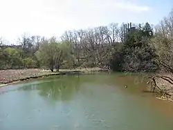
 Raccoon Creek near its mouth | |
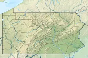
 Location of Raccoon Creek mouth | |
| Location | |
| Country | United States |
| State | Pennsylvania |
| Counties | Beaver County Washington County, Pennsylvania, U.S. |
| Physical characteristics | |
| Source | divide between Raccoon Creek and Chartiers Creek[1] |
| • location | Hickory, Pennsylvania[2] |
| • coordinates | 40°18′15″N 080°19′21″W / 40.30417°N 80.32250°W[3] |
| • elevation | 1,200 ft (370 m)[4] |
| Mouth | Ohio River |
• location | Ohioview, Pennsylvania[5] |
• coordinates | 40°39′46″N 080°21′04″W / 40.66278°N 80.35111°W[6] |
• elevation | 700 ft (210 m) |
| Length | 47.7 mi (76.8 km)[7] |
| Basin size | 477.21 square kilometres (184.25 sq mi)[8] |
| Discharge | |
| • location | Ohio River |
| • average | 204.08 cu ft/s (5.779 m3/s) at mouth with Ohio River[9] |
| Basin features | |
| Progression | north |
| River system | Ohio River |
| Tributaries | |
| • left | Burgetts Fork Brush Run Wingfield Run Traverse Creek Little Traverse Creek Frames Run Gum Run Fishpot Run |
| • right | Cherry Run Little Raccoon Run Chamberlain Run Potato Garden Run Rareden Run |
| Waterbodies | Cherry Valley Reservoir |
Raccoon Creek is a tributary of the Ohio River in Beaver County, Pennsylvania. Raccoon Creek joins the Ohio River in Potter Township. Only a small portion of the creek is located within Raccoon Creek State Park. The stream within the park is Little Traverse Creek.
See also
References
- ↑ "Raccoon Creek State Park Topo Map, Beaver County PA (Hookstown Area)". TopoZone. Locality, LLC. Retrieved 28 July 2019.
- ↑ "Raccoon Creek State Park Topo Map, Beaver County PA (Hookstown Area)". TopoZone. Locality, LLC. Retrieved 28 July 2019.
- ↑ "GNIS Detail - Raccoon Creek". geonames.usgs.gov. US Geological Survey. Retrieved 28 July 2019.
- ↑ "Raccoon Creek State Park Topo Map, Beaver County PA (Hookstown Area)". TopoZone. Locality, LLC. Retrieved 28 July 2019.
- ↑ "Raccoon Creek State Park Topo Map, Beaver County PA (Hookstown Area)". TopoZone. Locality, LLC. Retrieved 28 July 2019.
- ↑ "GNIS Detail - Raccoon Creek". geonames.usgs.gov. US Geological Survey. Retrieved 28 July 2019.
- ↑ 20D Raccoon Creek Region Conservation Plan (PDF). 2014. p. 11.
- ↑ "Raccoon Creek Watershed Report". Waters Geoviewer. US EPA. Retrieved 2020-10-30.
- ↑ "Raccoon Creek Watershed Report". Waters Geoviewer. US EPA. Retrieved 28 July 2019.
External links
- U.S. Geological Survey Geographic Names Information System: Raccoon Creek
- U.S. Geological Survey: PA stream gaging stations
This article is issued from Wikipedia. The text is licensed under Creative Commons - Attribution - Sharealike. Additional terms may apply for the media files.