Račiněves | |
|---|---|
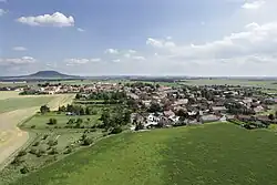
 Aerial view | |
 Flag  Coat of arms | |
 Račiněves Location in the Czech Republic | |
| Coordinates: 50°22′23″N 14°13′7″E / 50.37306°N 14.21861°E | |
| Country | |
| Region | Ústí nad Labem |
| District | Litoměřice |
| First mentioned | 1262 |
| Area | |
| • Total | 11.14 km2 (4.30 sq mi) |
| Elevation | 227 m (745 ft) |
| Population (2023-01-01)[1] | |
| • Total | 634 |
| • Density | 57/km2 (150/sq mi) |
| Time zone | UTC+1 (CET) |
| • Summer (DST) | UTC+2 (CEST) |
| Postal code | 413 01 |
| Website | www |
Račiněves is a municipality and village in Litoměřice District in the Ústí nad Labem Region of the Czech Republic. It has about 600 inhabitants.
Račiněves lies approximately 19 kilometres (12 mi) south of Litoměřice, 34 km (21 mi) south of Ústí nad Labem, and 36 km (22 mi) north-west of Prague.
Archaeology
Račiněves is home to an important archaeological site, at which numerous stone tools dating to the Lower Palaeolithic were found.[2]
Gallery
 Northert part
 Church of Saint Gall
 Western part
References
- ↑ "Population of Municipalities – 1 January 2023". Czech Statistical Office. 2023-05-23.
- ↑ Szymanek, Marcin; Julien, Marie-Anne (2018). "Early and Middle Pleistocene climate-environment conditions in Central Europe and the hominin settlement record". Quaternary Science Reviews. Elsevier BV. 198: 56–75. doi:10.1016/j.quascirev.2018.08.021. ISSN 0277-3791.
Wikimedia Commons has media related to Račiněves.
This article is issued from Wikipedia. The text is licensed under Creative Commons - Attribution - Sharealike. Additional terms may apply for the media files.