Pyhäntä | |
|---|---|
Municipality | |
| Pyhännän kunta Pyhäntä kommun | |
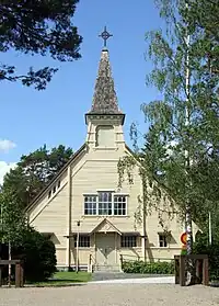
 Pyhäntä Church | |
 Coat of arms | |
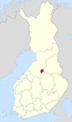
 Location of Pyhäntä in Finland | |
| Coordinates: 64°06′N 026°20′E / 64.100°N 26.333°E | |
| Country | |
| Region | North Ostrobothnia |
| Sub-region | Siikalatva |
| Charter | 1899 |
| Government | |
| • Municipal manager | Ismo Mäkeläinen |
| Area (2018-01-01)[1] | |
| • Total | 847.48 km2 (327.21 sq mi) |
| • Land | 810.16 km2 (312.80 sq mi) |
| • Water | 36.72 km2 (14.18 sq mi) |
| • Rank | 96th largest in Finland |
| Population (2023-09-30)[2] | |
| • Total | 1,647 |
| • Rank | 276th largest in Finland |
| • Density | 2.03/km2 (5.3/sq mi) |
| Population by native language | |
| • Finnish | 93.8% (official) |
| • Others | 6.2% |
| Population by age | |
| • 0 to 14 | 21.7% |
| • 15 to 64 | 54.9% |
| • 65 or older | 23.4% |
| Time zone | UTC+02:00 (EET) |
| • Summer (DST) | UTC+03:00 (EEST) |
| Website | www.pyhanta.fi |
Pyhäntä is a municipality of Finland. It is located in the Northern Ostrobothnia region. The municipality has a population of 1,647 (30 September 2023)[2] and covers an area of 847.48 square kilometres (327.21 sq mi) of which 36.72 km2 (14.18 sq mi) is water.[1] The population density is 2.03 inhabitants per square kilometre (5.3/sq mi). The municipality is unilingually Finnish.
Geography
Neighbouring municipalities are Kajaani, Kiuruvesi, Kärsämäki, Pyhäjärvi, Siikalatva, and Vieremä.
Nature
There are several conservation areas located in the municipality. About 60% of the area is covered by swamps. Surface variation is larger compared to typical flat landscape in Ostrobothnia. One of the biggest lakes in the region is Iso Lamujärvi.
Villages
- Ahokylä
- Ojalankylä
- Lamujoki
- Tavastkenkä
- Viitamäki
References
- 1 2 "Area of Finnish Municipalities 1.1.2018" (PDF). National Land Survey of Finland. Retrieved 30 January 2018.
- 1 2 "Preliminary population statistics 2023, September". StatFin. Statistics Finland. Retrieved 26 October 2023.
- ↑ "Demographic Structure by area as of 31 December 2022". Statistics Finland's PX-Web databases. Statistics Finland. Retrieved 6 September 2023.
- ↑ "Population according to age (1-year) and sex by area and the regional division of each statistical reference year, 2003–2020". StatFin. Statistics Finland. Retrieved 2 May 2021.
External links
![]() Media related to Pyhäntä at Wikimedia Commons
Media related to Pyhäntä at Wikimedia Commons
- Municipality of Pyhäntä – Official website (in Finnish)
