Highway 870 | ||||
|---|---|---|---|---|
| Ruta 870 | ||||
| Route information | ||||
| Maintained by Puerto Rico DTPW | ||||
| Length | 2.1 km[1] (1.3 mi) | |||
| Major junctions | ||||
| South end | ||||
| North end | Isla de Cabras in Palo Seco | |||
| Location | ||||
| Country | United States | |||
| Territory | Puerto Rico | |||
| Municipalities | Toa Baja | |||
| Highway system | ||||
| ||||
Puerto Rico Highway 870 (PR-870) is a road located entirely in the municipality of Toa Baja, Puerto Rico.[2] With a length of 2.1 kilometers (1.3 mi), it begins at its intersection with PR-165 and ends at Isla de Cabras, passing through Palo Seco neighborhood.[1]
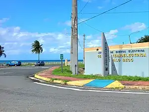
 Puerto Rico Highway 870 north in Palo Seco
Major intersections
The entire route is located in Palo Seco, Toa Baja.
| km[1] | mi | Destinations | Notes | ||
|---|---|---|---|---|---|
| 0.0 | 0.0 | PR-165 | Southern terminus of PR-870; access to Cataño and Dorado; unsigned | ||
| 2.1 | 1.3 | Northern terminus of PR-870 at Isla de Cabras; dead end road | |||
| 1.000 mi = 1.609 km; 1.000 km = 0.621 mi | |||||
See also
References
- 1 2 3 Google (17 August 2020). "PR-870" (Map). Google Maps. Google. Retrieved 17 August 2020.
- ↑ "PR-870, Toa Baja, Puerto Rico". geoview.info. Retrieved 25 May 2021.
External links
 Media related to Puerto Rico Highway 870 at Wikimedia Commons
This article is issued from Wikipedia. The text is licensed under Creative Commons - Attribution - Sharealike. Additional terms may apply for the media files.
